Dunga Gali
This article needs additional citations for verification. (August 2014) |

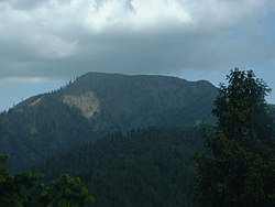
Dunga Gali or Doonga Gali also known as Zila Doonga is one of the towns of the Galyat area of Ayubia National Park, at an altitude of 2,500 metres (8,200 ft) in northern Pakistan. Dunga Gali is located in Nathia Gali Union Council (subdivision) of Abbottabad District in the Khyber Pakhtunkhwa Province.[1] It is 3 kilometres (1.9 mi) from Nathia Gali.[2]
History[]
During British Rule, Doonga Gali served as a sanatorium to Indians and contained a hotel, including a post office. The area was also visited by Europeans, who also had houses on the southern slopes of the nearby Mukeshpuri Temple, located in the Mukeshpuri Mountains.[3]
See also[]
References[]
- ^ "Dunga Gali". Faridbinmasood.wordpress.com. Retrieved 20 June 2018.
- ^ "Distance from Nathia Gali". Nathiagali.com. Retrieved 20 June 2018.
- ^ Imperial Gazetteer of India, v. 11, p. 379
Coordinates: 34°03′20″N 73°25′0″E / 34.05556°N 73.41667°E

This Abbottabad District location article is a stub. You can help Wikipedia by . |
- Hill stations in Pakistan
- Populated places in Abbottabad District
- Galyat of Pakistan
- Abbottabad District geography stubs