Dyrøya, Troms
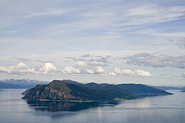 View of the island | |
 Dyrøya Location of the island | |
| Geography | |
|---|---|
| Location | Troms og Finnmark, Norway |
| Coordinates | 68°59′37″N 17°22′13″E / 68.9937°N 17.3703°ECoordinates: 68°59′37″N 17°22′13″E / 68.9937°N 17.3703°E |
| Area | 53 km2 (20 sq mi) |
| Length | 15 km (9.3 mi) |
| Width | 6 km (3.7 mi) |
| Highest elevation | 563 m (1847 ft) |
| Highest point | Bergsheia |
| Administration | |
Norway | |
| County | Troms og Finnmark |
| Municipality | Dyrøy Municipality |
| Demographics | |
| Population | 152[1] (2017) |
| Pop. density | 2.9/km2 (7.5/sq mi) |


Dyrøya is an island in Dyrøy Municipality in Troms og Finnmark county, Norway. The 53-square-kilometre (20 sq mi) island is located between the large island of Senja and the mainland of Norway. The strait lies to the east of the island (towards the mainland) and the lies to the north and west (towards Senja). The island of Andørja lies about 7 kilometres (4.3 mi) south of Dyrøya.[2]
The island is connected to the mainland by the Dyrøy Bridge, east of the village of Brøstadbotn. The largest village area on the island is on the central part of the eastern coastline of Dyrøya, including Holm, where Dyrøy Church is located.
See also[]
References[]
- ^ https://snl.no/Dyrøya_-_øy_i_Dyrøy
- ^ Store norske leksikon. "Dyrøya – øy i Dyrøy" (in Norwegian). Archived from the original on 2013-02-23. Retrieved 2012-10-24.
This article about an island in Troms og Finnmark is a stub. You can help Wikipedia by . |
Categories:
- Dyrøy
- Islands of Troms og Finnmark
- Troms og Finnmark geography stubs
- Troms og Finnmark island stubs