Dzūkija National Park
| Dzūkija National Park | |
|---|---|
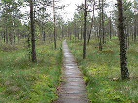 Čepkeliai marsh in Dzūkija National Park | |
 | |
| Location | Lithuania |
| Nearest city | Varėna |
| Coordinates | 54°04′55″N 24°22′36″E / 54.08194°N 24.37667°ECoordinates: 54°04′55″N 24°22′36″E / 54.08194°N 24.37667°E |
| Area | 584.53 km2 (225.69 sq mi) |
| Established | 1991 |
| Visitors | 30,000 |

Dzūkija National Park - a national park in Dzūkija, Lithuania, was established in 1991 in order to preserve the pine forests, the landscape, and the villages of the region. The area encompasses 584.53 square kilometers on the banks of the Nemunas River.[1]
The park is the largest protected area in Lithuania. It belongs to both the and the .[2]
Features[]
The park enjoys a more continental climate than other parts of the country. Its most distinctive landscapes are the mainland dune massifs located in Marcinkonys, Lynežeris, Grybaulia, and .
Settlements[]
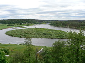
Nemunas near Merkinė
The administrative center of the park is in Marcinkonys and the other important town is Merkinė. The ethnographic village of Zervynos can be found within the park.
See also[]
References[]
- ^ Dzukijos Nacionalinis Parkas in Lithuania Protected Planet
- ^ "GENERAL INFORMATION". Archived from the original on 2007-11-16. Retrieved 2007-09-21.
External links[]
Categories:
- IUCN Category II
- National parks of Lithuania
- Protected areas established in 1991
- 1991 establishments in Lithuania
- Tourist attractions in Alytus County