eSikhawini
ESikhawini (somewhere between Richards bay and empangeni) | |
|---|---|
 ESikhawini (somewhere between Richards bay and empangeni) | |
| Coordinates: 28°53′S 31°54′E / 28.883°S 31.900°ECoordinates: 28°53′S 31°54′E / 28.883°S 31.900°E | |
| Country | South Africa |
| Province | KwaZulu-Natal |
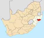
| District | King Cetshwayo |
| Municipality | uMhlathuze |
| Area | |
| • Total | 5.90 km2 (2.28 sq mi) |
| Population (2001)[1] | |
| • Total | 32,437 |
| • Density | 5,500/km2 (14,000/sq mi) |
| Racial makeup (2001) | |
| • Black African | 99.8% |
| • Coloured | 0.1% |
| First languages (2001) | |
| • Zulu | 98.5% |
| Time zone | UTC+2 (SAST) |


eSikhawini is a town in King Cetshwayo District Municipality in the KwaZulu-Natal province of South Africa.
eSikhawini is located 2 km off the N2 route. Richards Bay and Empangeni are closest towns, being both located 15–20 km away. It was established in 1976 as a black township consisting of middle income residents.[2]
Sports facilities[]
- Esikhawini H Ground
- Esikhawini College
Places[]
- Esikhawini J
- Esikhawini H
- Found on the northern outskirts of the H section it is one of the oldest villages of Esikhawini. Dube Village is led by the chief Matamzana Dube and with some influences from politics, ANC being the governing party in the area.
References[]
- ^ Jump up to: a b c d "Main Place ESikhawini". Census 2001.
- ^ "Planning for Recreational Facilities and Open Spaces: A Case Study of ESikhawini Township at Umhlathuze Municipality, KwaZulu Natal" (PDF). University of KwaZulu-Natal. Retrieved 4 January 2014.
| show Municipalities and communities of King Cetshwayo District Municipality, KwaZulu-Natal |
|---|
| show Authority control |
|---|
This KwaZulu-Natal location article is a stub. You can help Wikipedia by . |
Categories:
- Populated places in the uMhlathuze Local Municipality
- Townships in KwaZulu-Natal
- Populated places established in 1976
- KwaZulu-Natal geography stubs