East Jensen Island
Øst Jensens Ø | |
|---|---|
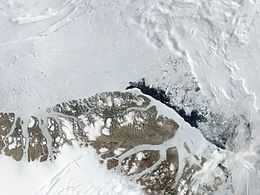 Satellite image of the northern end of Greenland | |
 East Jensen Island | |
| Geography | |
| Location | Lincoln Sea |
| Coordinates | 83°3′N 40°36′W / 83.050°N 40.600°WCoordinates: 83°3′N 40°36′W / 83.050°N 40.600°W |
| Area | 163.7 km2 (63.2 sq mi) |
| Length | 23 km (14.3 mi) |
| Width | 9 km (5.6 mi) |
| Coastline | 57.2 km (35.54 mi) |
| Highest elevation | 853.44 m (2800 ft) |
| Administration | |
| Zone | Northeast Greenland National Park |
| Demographics | |
| Population | 0 |

East Jensen Island (Danish: Øst Jensens Ø) is an uninhabited island of the Lincoln Sea in Peary Land, far northern Greenland.
The island was named after Danish zoologist (1866 - 1953), professor at the University of Copenhagen, who had carried out extensive research on the fisheries of West Greenland, and who was a member of the committee of the 1931–34 Three-year Expedition (Treårsekspeditionen).
Geography[]
East Jensen Island is located off the western side of Hazenland in the De Long Fjord. The island has an area of 163.7 km2 (63.2 sq mi) and a shoreline of 57.2 km (35.5 mi).[1]
Its western shore forms the eastern side of , beyond which lies West Jensen Island. Small and narrow , located at the mouth of De Long Fjord lies 3 km to the north off the northern end of East Jensen Island.[2]
 Map of Northern Ellesmere Island and far Northern Greenland. |
See also[]
References[]
This Greenland location article is a stub. You can help Wikipedia by . |
- Uninhabited islands of Greenland
- Greenland geography stubs