Edelény District
Edelény District
Edelényi járás | |
|---|---|
 Coat of arms | |
 Edelény District within Hungary and Borsod-Abaúj-Zemplén County. | |
| Country | |
| County | Borsod-Abaúj-Zemplén |
| District seat | Edelény |
| Area | |
| • Total | 717.86 km2 (277.17 sq mi) |
| Area rank | 3rd in Borsod-Abaúj-Zemplén |
| Population (2011 census) | |
| • Total | 33,314 |
| • Rank | 6th in Borsod-Abaúj-Zemplén |
| • Density | 46/km2 (120/sq mi) |
Edelény (Hungarian: Edelényi járás) is a district in northern part of Borsod-Abaúj-Zemplén County. Edelény is also the name of the town where the district seat is found. The district is located in the Northern Hungary Statistical Region.
Geography[]
Edelény District borders with the Slovakian region of Košice to the north, Encs District and Szikszó District to the east, Miskolc District to the south, Kazincbarcika District and Putnok District to the west. The number of the inhabited places in Edelény District is 45.
Municipalities[]
The district has 2 towns and 43 villages. (ordered by population, as of 1 January 2012)[1]
- Abod (229)
- Balajt (463)
- Becskeháza (44)
- Boldva (2,331)
- Bódvalenke (184)
- Bódvarákó (94)
- Bódvaszilas (1,005)
- Borsodszirák (1,199)
- Damak (234)
- Debréte (21)
- Edelény (10,019) – district seat
- Égerszög (43)
- Galvács (91)
- Hangács (573)
- Hegymeg (104)
- Hidvégardó (507)
- Irota (67)
- Komjáti (254)
- Lak (604)
- Ládbesenyő (271)
- Martonyi (374)
- Meszes (157)
- Nyomár (327)
- Perkupa (819)
- Rakaca (725)
- Rakacaszend (338)
- Szakácsi (132)
- Szalonna (1,027)
- Szendrő (4,062)
- Szendrőlád (2,062)
- Szin (738)
- Szinpetri (220)
- Szögliget (606)
- Szőlősardó (100)
- Szuhogy (1,184)
- Teresztenye (20)
- Tomor (219)
- Tornabarakony (15)
- Tornakápolna (23)
- Tornanádaska (688)
- Tornaszentandrás (193)
- Tornaszentjakab (203)
- Varbóc (46)
- Viszló (62)
- Ziliz (348)
The bolded municipalities are cities.
Demographics[]
Religion in Edelény District (2011 census)
In 2011, it had a population of 33,314 and the population density was 46/km².
| Year | County population[2] | Change |
|---|---|---|
| 2011 | 33,314 | n/a |
Ethnicity[]
Besides the Hungarian majority, the main minorities are the Roma (approx. 6,000), Polish and Rusyn (150) and German (130).
Total population (2011 census): 33,314
Ethnic groups (2011 census):[3] Identified themselves: 36,295 persons:
- Hungarians: 29,602 (81.56%)
- Gypsies: 6,052 (16.67%)
- Others and indefinable: 641 (1.77%)
Approx. 3,000 persons in Edelény District did declare more than one ethnic group at the 2011 census.
Religion[]
Religious adherence in the county according to 2011 census:[4]
- Catholic – 17,695 (Roman Catholic – 15,213; Greek Catholic – 2,480);
- Reformed – 6,666;
- other religions – 308;
- Non-religious – 2,251;
- Atheism – 120;
- Undeclared – 6,274.
Gallery[]

Ruins of Szendrő Castle
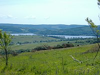
Reservoir near Rakaca
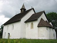
St. Andrew Church in Tornaszentandrás


See also[]
- List of cities and towns of Hungary
- Edelény Subregion (until 2013)
References[]
- ^ A KSH 2012. évi helységnévkönyve
- ^ népesség.com, "Edelényi járás népessége"
- ^ 4.1.6.1 A népesség nemzetiség szerint, 2011, (in Hungarian) [1]
- ^ 4.1.7.1 A népesség vallás, felekezet szerint, 2011, (in Hungarian) [2]
External links[]
Coordinates: 48°23′00″N 20°47′00″E / 48.3833°N 20.7833°E

This Borsod-Abaúj-Zemplén location article is a stub. You can help Wikipedia by . |
- Districts in Borsod-Abaúj-Zemplén County
- Borsod-Abaúj-Zemplén geography stubs