El Calafate
El Calafate | |
|---|---|
 | |
 Flag  Coat of arms | |
 El Calafate Location of El Calafate in Argentina | |
| Coordinates: 50°20′S 072°17′W / 50.333°S 72.283°WCoordinates: 50°20′S 072°17′W / 50.333°S 72.283°W | |
| Country | |
| Province | |
| Department | Lago Argentino |
| Population (2010 census) | |
| • Total | 6,143 |
| Demonym(s) | calafateño/a |
| Time zone | UTC-3 (ART) |
| CPA base | Z9405 |
| Dialing code | +54 2965 |
| Climate | BSk |
| Website | www |


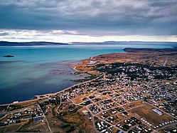
El Calafate is a city in Patagonia, Argentina. It is situated on the southern border of Lake Argentino, in the southwest part of the Santa Cruz Province, about 320 kilometres (200 mi) northwest of Río Gallegos. The name of the city is derived from a little bush with yellow flowers and dark blue berries that is very common in Patagonia: the calafate (Berberis buxifolia); the word comes from the word calafate, which is Spanish for 'caulk'.
El Calafate is an important tourist destination as the hub to visit different parts of the Los Glaciares National Park, including Perito Moreno Glacier, Cerro Chaltén, and Cerro Torre.
History[]
This section does not cite any sources. (June 2012) |
The history of El Calafate began in the first decades of the twentieth century. Originally, it was simply a sheltering place for wool traders. The town was officially founded in 1927 by the government of Argentina to promote settlement, but it was the creation of nearby Perito Moreno National Park in 1937 that sparked growth and the building of better road access.
Transport[]
The 220 kilometers separating Calafate from El Chaltén on the other side of the Lake Argentino in the national park are paved, as well as the 315 kilometres to Río Gallegos. Other distances are: to Bariloche 1400 km ; to Esquel 1108 km (some dirt road[1]); Comodoro Rivadavia 959 km; Puerto Madryn 1388 km; Buenos Aires 2727 km; Ushuaia 863 km.
The town is served by El Calafate International Airport (IATA: FTE, ICAO: SAWC) located some 20 km east of the village.

Avenida del Libertador, the town's main street

Residential section

El Calafate is gateway to Los Glaciares National Park

Ice and Glaciers interpretation Centre, Glaciarium.


Population[]
In the last census 6,143 permanent residents were counted (2001 census [INDEC]). This represents a 20.1% increase compared with the 1991 census.[2] However, due to the expansion of tourism, the population was estimated at 20,000 people in 2014.
Wildlife[]
Flamingos are regularly visible from El Calafate congregating in the waters of Lago Argentino.[3]
Climate[]
El Calafate experiences a cold semi-arid climate (Köppen BSk) with cool to warm, very dry summers and cool to cold, slightly wetter winters. The city's extremes of cold and heat are moderated by the influence of Lago Argentino. The waterfront of the city is located on a large shallow bay that is often frozen in the winter, allowing residents to practice ice skating. The highest temperature recorded was 30.7 °C (87.3 °F) on February 6, 1962[4] while the lowest recorded temperature was −17.4 °C (0.7 °F) on July 27, 2014.[5]
| hideClimate data for El Calafate (Lago Argentino Airport) 1961–1990, extremes 1951–present[a] | |||||||||||||
|---|---|---|---|---|---|---|---|---|---|---|---|---|---|
| Month | Jan | Feb | Mar | Apr | May | Jun | Jul | Aug | Sep | Oct | Nov | Dec | Year |
| Record high °C (°F) | 30.5 (86.9) |
30.7 (87.3) |
27.0 (80.6) |
24.3 (75.7) |
20.8 (69.4) |
18.0 (64.4) |
16.5 (61.7) |
21.0 (69.8) |
21.8 (71.2) |
23.3 (73.9) |
26.2 (79.2) |
28.5 (83.3) |
30.7 (87.3) |
| Average high °C (°F) | 18.7 (65.7) |
18.5 (65.3) |
16.3 (61.3) |
12.5 (54.5) |
7.7 (45.9) |
5.2 (41.4) |
4.3 (39.7) |
6.6 (43.9) |
10.4 (50.7) |
13.8 (56.8) |
16.3 (61.3) |
17.9 (64.2) |
12.3 (54.1) |
| Daily mean °C (°F) | 13.1 (55.6) |
12.9 (55.2) |
10.8 (51.4) |
7.6 (45.7) |
4.0 (39.2) |
1.6 (34.9) |
0.7 (33.3) |
2.6 (36.7) |
5.3 (41.5) |
8.3 (46.9) |
10.8 (51.4) |
12.3 (54.1) |
7.5 (45.5) |
| Average low °C (°F) | 7.7 (45.9) |
7.5 (45.5) |
5.6 (42.1) |
3.1 (37.6) |
0.2 (32.4) |
−2.0 (28.4) |
−2.8 (27.0) |
−1.2 (29.8) |
0.7 (33.3) |
2.9 (37.2) |
5.1 (41.2) |
6.7 (44.1) |
2.8 (37.0) |
| Record low °C (°F) | −2.2 (28.0) |
−2.2 (28.0) |
−6.8 (19.8) |
−9.6 (14.7) |
−12.4 (9.7) |
−16.6 (2.1) |
−17.4 (0.7) |
−15.2 (4.6) |
−9.0 (15.8) |
−8.0 (17.6) |
−5.6 (21.9) |
−5.0 (23.0) |
−17.4 (0.7) |
| Average precipitation mm (inches) | 12.5 (0.49) |
7.8 (0.31) |
13.8 (0.54) |
25.4 (1.00) |
30.6 (1.20) |
21.3 (0.84) |
25.8 (1.02) |
21.1 (0.83) |
15.8 (0.62) |
12.3 (0.48) |
9.1 (0.36) |
13.9 (0.55) |
209.4 (8.24) |
| Average precipitation days (≥ 0.1 mm) | 4 | 3 | 5 | 8 | 8 | 6 | 7 | 6 | 5 | 5 | 4 | 4 | 65 |
| Average snowy days | 0.1 | 0 | 0.1 | 0.1 | 2 | 4 | 5 | 4 | 2 | 0.9 | 0 | 0 | 18.2 |
| Average relative humidity (%) | 47 | 48 | 53 | 60 | 70 | 74 | 76 | 70 | 61 | 53 | 48 | 47 | 59 |
| Mean monthly sunshine hours | 254.2 | 210.0 | 192.2 | 156.0 | 114.7 | 96.0 | 96.1 | 139.5 | 168.0 | 213.9 | 246.0 | 257.3 | 2,143.9 |
| Percent possible sunshine | 51 | 52 | 50 | 49 | 41 | 38 | 36 | 44 | 48 | 51 | 54 | 50 | 47 |
| Source 1: NOAA,[6] Secretaria de Mineria (extremes 1951–1980)[4] | |||||||||||||
| Source 2: Servicio Meteorológico Nacional (precipitation days 1961–1990 and extremes 1962–present)[7][5] UNLP (snowfall data)[8] | |||||||||||||
Attractions[]
El Calafate is the location of the Glaciarium, a museum that focuses on ice and glaciers, especially in the Southern Patagonian Ice Field.
Interesting facts[]
The most recent World Altitude Gliding record of 22,657 m (74,333 ft) was set near El Calafate on 2 September 2018 by Jim Payne and Tim Gardner in the new Perlan 2 glider (with pressurised cabin).[9]
A previous gliding altitude record of 15,460 m (50,722 feet) was set near El Calafate on 30 August 2006 by Steve Fossett and Einar Enevoldson in their 'Perlan' high altitude research glider.[10] This record has been certified by the Fédération Aéronautique Internationale.
The town was on the path of the total solar eclipse of July 11, 2010, occurring just before sunset. El Calafate was featured in the Top Gear Patagonia Special, in which the presenters drove from Bariloche to Ushuaia.
References[]
- ^ http://www.ruta0.com
- ^ Interior Ministry: El Calafate Archived 2009-03-31 at the Wayback Machine
- ^ UNEP World Conservation Monitoring Centre
- ^ Jump up to: a b "Provincia de Santa Cruz - Clima Y Meteorologia: Datos Meteorologicos Y Pluviometicos" (in Spanish). Secretaria de Mineria de la Nacion (Argentina). Archived from the original on July 2, 2015. Retrieved April 12, 2013.
- ^ Jump up to: a b "Clima en la Argentina: Guia Climática por El Calafate Aero". Caracterización: Estadísticas de largo plazo (in Spanish). Servicio Meteorológico Nacional. Archived from the original on 2017-09-04. Retrieved 9 October 2017.
- ^ "Lago Argentino Climate Normals 1961–1990". National Oceanic and Atmospheric Administration. Retrieved February 19, 2014.
- ^ "Valores Medios de Temperatura y Precipitación-Santa Cruz: El Calafate" (in Spanish). Servicio Meteorológico Nacional. Retrieved July 13, 2015.
- ^ "Datos bioclimáticos de 173 localidades argentinas". Atlas Bioclimáticos (in Spanish). Universidad Nacional de La Plata. Retrieved October 13, 2015.
- ^ List of FAI world records for open-class gliders
- ^ List of FAI world records for open-class gliders[permanent dead link]
Notes[]
- ^ The record highs and lows are based on the Secretaria de Mineria link for the period 1951–1980 while records beyond 1962 come from the Servicio Meteorológico Nacional link. When these two sources are used together, the record highs and lows are from the period 1951–present
External links[]
| Wikimedia Commons has media related to El Calafate. |
| Wikivoyage has a travel guide for El Calafate. |
- Elcalafate.gov.ar, Official government site (in Spanish)
- Glaciarium Website
| Authority control |
|
|---|
- Populated places in Santa Cruz Province, Argentina
- Populated places established in 1927
- Tourist attractions in Santa Cruz Province, Argentina
- Populated lakeshore places in Argentina