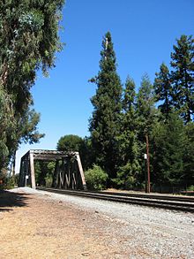
El Palo Alto
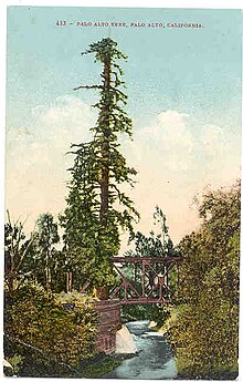
El Palo Alto (Spanish for 'the tall pole' or 'post', or "tall stick"[1]) is a coastal redwood (Sequoia sempervirens) located in El Palo Alto Park on the banks of San Francisquito Creek in Palo Alto, California, United States. It is famous for its historical significance and as the namesake of the city of Palo Alto.
As of July 2016, El Palo Alto is currently 110 feet (33.5 meters) in height, down from 162.2 feet (49.4 meters) in 1814. Its top progressively died from 1865 to 1955 from lowering of the water table so that its roots could no longer reach sustenance.[2] The landmark redwood is 90 inches (2.3 meters) in diameter, and has a crown spread of 40 feet (12 meters). In 1955, an increment boring of the tree was taken and the tree's age was accurately determined to be 1,015 years. El Palo Alto originally had 3 trunks.[3] It is unknown what happened to the first trunk; it remains as a stump attached to the current trunk. The second trunk fell in 1886, also for unknown reasons.[2]
History[]
The landmark redwood is 90 inches (2.3 meters) in diameter, and has a crown spread of 40 feet (12 meters). In 1955, an increment boring of the tree was taken and the tree's age was accurately determined to be 1,015 years by George Hood, arborist.[4] George Hood also rigged piping to deliver mist to the top of the tree. “He called it a ‘Fool the Redwood’ plan,” said David Dockter, a retired city arborist who helped care for the tree for more than two decades and still monitors its health. “Redwoods drink from their crown as well as their roots, and he wanted to fool the redwood into thinking it was on the coast, getting a drink of water every day when the fog came in.”[1]
A railroad line still runs next to the tree; the trains are no longer coal-fired steam engines. In 2021, they are diesel-fueled trains. There are plans to run electrically-powered trains on the line by 2024, which may offer cleaner air for the tree.[1]
El Palo Alto originally had 3 trunks.[5] It is unknown what happened to the first trunk; it remains as a stump attached to the current trunk. The second trunk fell in 1886, also for unknown reasons.[2]
The tree is California Historical Landmark No. 2 (No. 1 is the Old Customhouse in Monterey). It is recognized by the National Arborist Association and International Society of Arboriculture for its historical significance as "a campsite for the Portola Expedition Party of 1769"; being frequented by the Costanoan/Ohlone Indians; and for its use as a sighting tree by surveyors plotting out El Camino Real. The tree is depicted on the city of Palo Alto's official seal and on the seal of Stanford University. It is the origin of the city's name.[6]
A plaque at the base of the tree bears the following inscription:
- Under this giant redwood, the Palo Alto, November 6–11, 1769, camped Portola and his band on the expedition that discovered San Francisco Bay, this was the assembling point for their reconnoitering parties. Here in 1774 Padre Palou erected a cross to mark the site of a proposed mission. The celebrated Pedro Font topographical map of 1776 contained the drawing of the original double trunked tree making the Palo Alto the first official living California landmark.
It was two years after Padre Palou's visit that Padre Font, on the De Anza Expedition's way back to Mexico after founding San Francisco, measured the giant redwood "five and a half yards around" in his diary on March 30, 1776.[7] Also at El Palo Alto, de Anza and Font found the wooden cross that Palou had placed two years earlier, but de Anza decided to move the mission location to Santa Clara because San Francisquito Creek's water was too low in the dry season.[8]
Health of the tree and conservation[]


In 1776, the tree was measured at 135.7 feet with a circumference of 15.1 feet. In 1814, measurement found a height of 162.2 feet. However, from 1865 to 1955, the tree's health was in decline exhibiting sparse branching and foliage. In 1926, fearing the tree's loss, a bronze plaque commemorating the tree was set in a granite boulder by the local Native Sons of the Golden West. In 1951 its height was 134.6 feet, in 1977 its height was reduced to 126 feet to remove the dead top, and again in 1999 where it still stands at nearly 110 feet.
Causes of the tree's decline have been attributed to coal-burning locomotive soot and lowering of the water table by nearby orchard wells, including the 1912 Tower Well two blocks away. By the 1960s, the water table was so low that salt water was intruding into nearby wells. El Palo Alto was unable to access this lowered groundwater, as redwoods are typically shallow rooted.[9]
By the mid-1960s the tree was in severe decline, leading to successive die-off of the treetop, until the water table began to recover in the late 1990s. Efforts to restore the tree's health by the Southern Pacific Railroad, the City of Palo Alto and local citizens included progressive pruning of the dying treetop, addition of soil and mulch at the tree’s base, removal of dead limbs, pesticide spraying and installation of a pipe up its trunk to bring water to mist the top of the tree.[10][11] Although the tree stands today at only 68% of its former stature, it enjoys greater health than nearly a century ago.[12]
A 1999 horticultural appraisal of El Palo Alto, conducted in accordance with the Guide for Plant Appraisal authored by the Council of Tree and Landscape Appraisers and published by the International Society of Arboriculture, valued the tree at $55,600.00, but the tree’s true worth goes beyond dollars and was described thus: “the El Palo Alto redwood is considered to be an invaluable and priceless natural resource--and irreplaceable at any cost in the event of loss.”[2][4]
In 2004, seedlings from El Palo Alto were planted in the American Forests Historic Tree Nursery in Jacksonville, Florida.[13]
The tree was spray-painted with graffiti in August 2010,[14] but was subsequently cleaned.[15]
See also[]
References[]
- ^ Jump up to: a b c Robbins, Jim (June 26, 2021). "The Unlikely Survival of the 1,081-Year-Old Tree That Gave Palo Alto Its Name". The New York Times.
- ^ Jump up to: a b c d Dockter, Dave (September 18, 1999). "The El Palo Alto Redwood Tree - Arborist Report and Appraisal" (PDF). Planning Division Arborist. Palo Alto, California. Retrieved November 14, 2009.
- ^ Vischer, Edward (1870). Vischer's Pictorial of California. Claremont College, Honnold Mudd Library Special Collections: Joseph Winterburn & Company. p. 185.
- ^ Jump up to: a b Dockter, Dave (September 18, 1999). "The El Palo Alto Redwood Tree - Arborist Report and Appraisal, City Managers Report" (PDF). Heritage Tree #1 Arborist Report & Appraisal. Palo Alto, California. Retrieved June 26, 2021.
- ^ Vischer, Edward (1870). Vischer's Pictorial of California. Claremont College, Honnold Mudd Library Special Collections: Joseph Winterburn & Company. p. 185.
- ^ City of Palo Alto. El Palo Alto Historic Report
- ^ Pedro Font (1913). Frederick J. Teggart (ed.). The Anza Expedition of 1775-1776, Diary of Pedro Font. University of California. p. 77. Retrieved 2010-07-03.
- ^ de Anza, Juan Bautista (1776). Diary of Juan Bautista de Anza October 23, 1775 - June 1, 1776. University of Oregon Web de Anza pages. Archived from the original on July 17, 2011. Retrieved 2010-10-13.
- ^ Spring, Cindy (Jul–Sep 2004). "Saving El Palo Alto: Interview with Jim Johnson". Bay Nature.
- ^ Bowling, Matt. "El Palo Alto: An Iconic Past - The Palo Alto History Project". Archived from the original on 2009-11-21. Retrieved Nov 13, 2009.
- ^ Bowling, Matt. "El Palo Alto: Rooted in History". Palo Alto History. Retrieved Oct 15, 2018.
- ^ "El Palo Alto As It Stands Today". City of Palo Alto. Retrieved Nov 13, 2009.
- ^ Kaller, Karl; Schmitt, Kellie (October 14, 2004). "Palo Alto's Namesake Honored". San Jose Mercury News.
- ^ "El Palo Alto tree sprayed with graffiti". Palo Alto Online. August 12, 2010.
- ^ "El Palo Alto restored by 'hero' with a light touch". Palo Alto Online. August 20, 2010.
External links[]
| Wikimedia Commons has media related to El Palo Alto. |
- Visual essay on the history of El Palo Alto
- El Palo Alto at Paloaltohistory.org
- City of Palo Alto's Heritage Trees
- Stanford University History: Prologue
- Historical photographs of San Francisquito Creek, including El Palo Alto
- City Arborist Report, 1999
- Famous Redwoods
Coordinates: 37°26′50″N 122°10′13″W / 37.44727°N 122.17014°W

- Individual coast redwood trees
- Individual trees in California
- Palo Alto, California
- History of Santa Clara County, California
- History of the San Francisco Bay Area
- Native American history of California
- Natural history of the California Coast Ranges
- Geography of Santa Clara County, California
- Tourist attractions in Santa Clara County, California