El Yunque (Puerto Rico)
- This article refers to the mountain. For information on the national forest, see El Yunque National Forest.
| Pico El Yunque | |
|---|---|
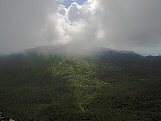
 View of El Yunque from the Yokahú Tower in Río Grande, Puerto Rico | |
| Highest point | |
| Elevation | 1,080 m (3,540 ft) |
| Parent peak | El Toro |
| Coordinates | 18°18′38″N 65°47′29″W / 18.31056°N 65.79139°WCoordinates: 18°18′38″N 65°47′29″W / 18.31056°N 65.79139°W |
| Naming | |
| Etymology | Yúcahu phonetic Spanish transliteration of Taíno possibly meaning 'white land' and/or El Yunque meaning 'the anvil' in Spanish due to the shape of the mountain range when seen from the south. |
| Geography | |
 Pico El Yunque | |
| Parent range | Sierra de Luquillo |
| Climbing | |
| Easiest route | Hike |

Pico El Yunque or El Yunque Peak is a mountain that is located fully within the boundaries of the El Yunque National Forest, part of the U.S. Forest Service, which is the only tropical rainforest under the U.S. Forest Service jurisdiction. It is located in the municipality of Río Grande. The peak itself, standing at 1,080 metres (3,540 feet) above sea level is not the highest in Puerto Rico or even the Sierra de Luquillo range where it is located. It is however the most famous peak due to its curious shape, its natural beauty and history, and for its cultural importance to the Taino people. The peak is nearly always covered in thin mist and, due to its high humidity, a quick shower develops during some afternoons. The hike to the top from the Mina Falls is not challenging yet it takes almost 4 and a half hours.
This peak is located on the El Yunque massif which also contains other famous smaller peaks such as Mount Britton, Juan Diego Peak and the Roca del Yunque which is a rocky peak close to the summit of El Yunque. El Yunque massif itself is part of the Sierra de Luquillo. The highest point in the Sierra de Luquillo is El Toro (Spanish for the bull) located in the municipal boundary between Río Grande and Las Piedras, which lends its name to the El Toro Wilderness.

Climate[]
El Yunque is classified as having a tropical rainforest climate, Köppen climate type 'Af', along with surrounding areas. The average temperature of the park is 21 °C, and seasonal variation virtually nonexistent. The rugged area can receive over 200 inches (5080 millimeters) of annual rainfall and is the rainiest of all US national forests.[1][2][3]
Gallery[]
El Yunque view from Mount Britton Tower.

El Yunque view from Yokahu Tower.

El Yunque massif with Pico El Yunque, Roca El Yunque and Mount Britton.


See also[]
References[]
- ^ "About the Forest MAIN". USDA Forest Service. Retrieved 2020-03-25. USDA Forest Service
- ^ "Naguabo, Puerto Rico". weatherbase.com. Retrieved 25 January 2015.
- ^ "El Yunque, Puerto Rico". welcome.topuertorico.org. Retrieved 2018-10-30.
External links[]
 Media related to El Yunque (Puerto Rico) at Wikimedia Commons
| hide Authority control | |
|---|---|
| General |
|
| National libraries | |
This Río Grande, Puerto Rico location article is a stub. You can help Wikipedia by . |
- Mountains of the Caribbean
- Mountains of Puerto Rico
- Río Grande, Puerto Rico
- Puerto Rico Senatorial district VIII geography stubs
- Sacred mountains
- Protected areas of Puerto Rico
- American folklore