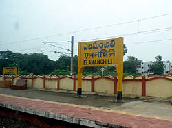
Elamanchili
Elamanchili | |
|---|---|
Town | |
 Elamanchili Railway Station | |
 Elamanchili Location in Andhra Pradesh, India | |
| Coordinates: 17°33′6″N 82°51′15″E / 17.55167°N 82.85417°E | |
| Country | |
| State | Andhra Pradesh |
| District | Visakhapatnam |
| Government | |
| • Type | Municipality |
| • Body | , Visakhapatnam Metropolitan Region Development Authority |
| • MLA | Uppalapati Venkata Ramanamurthy Raju |
| Area | |
| • Total | 39.00 km2 (15.06 sq mi) |
| Elevation | 7 m (23 ft) |
| Population | |
| • Total | 27,265 |
| • Density | 700/km2 (1,800/sq mi) |
| Languages | |
| • Official | Telugu |
| Time zone | UTC+5:30 (IST) |
| PIN | 531055 |
| Telephone code | 08931 |
| Vehicle Registration | AP31 (Former) AP39 (from 30 January 2019)[3] |
Elamanchili is a town in Visakhapatnam district of the Indian state of Andhra Pradesh. It is a municipality and also the mandal headquarters of Elamanchili mandal. The town is spread over an area of 39 km2 (15 sq mi), which is under the jurisdiction of Visakhapatnam Metropolitan Region Development Authority.[4] This town has historical importance dating back to 7th Century AD.

History[]
Elamanchilii was once called as ella - majili, which is the border village of Kalinga and Andhra empires. This place was used for the collection of taxes as it is on the border of these areas. Kalla Varahala Naidu (Vara Naidu) The King Of Elamanchili.
Many Historical and archaeological evidences were found in the surroundings of Elamanchili dating back the history of this town to the times of Early Buddhism in India, Jainism and Medieval Hinduism. The Kotturu Dhanadibbalu Buddhist and Dharapalem Hindu sites respectively are near this town. This particular area of Elamanchili was once under the rule of Andhra-Sathavahanas. Some Pre-historic findings were excavated from the surroundings of Panchadharla, Dharapalem and Elamanchili surrounding Hills of Eastern Ghats. Research work is under progress on these excavations, and recently found lord venkateswara swamy statue.
The village of Sarvasiddhi (10 km from Elamanchili) was constructed by Eastern Chalukyas King Kubja Vishnuvardhan during 615 CE. Vishnuvardhana ruled over a kingdom extending from Nellore to Visakhapatnam. He assumed the title of Vishamasiddhi (conqueror of difficulties). Vishnuvardhana participated in the wars between his brother Putekesin II and the Pallava Narasimhavarma I and probably lost his life in battle in 641 CE. This area was under the Eastern Chalukyas. Elamanchili was under the rule of Eastern Chalukyas as some edicts were found by the name of Vijayaditya VII (1063 – 1068 C.E., 1072 – 1075 C.E.) at Elamanchili.
The famous Dharmalingeswara Temple at Panchadharla was believed to be constructed along with the famous
Demographics[]
Transport[]

Elamanchili is well connected by rail and road. Elamanchili railway station provide halt for many express trains. Buses are available from all parts of area in the state. Nearest airport is Visakhapatnam International Airport which is about 54 km from the town.
Legislative Assembly[]
- 1951-1954 - N/A
- 1955-1962 - Venkata Surya Narayana Raju Chintlapat
- 1962-1967 - Veesam Sanyasi Naidu
- 1966-1972 - Satyanarayana Nagireddi
- 1972-1978 - Kumara Venkata Satya Narayana Raju Kakarlapudi (K K Raju)
- 1978-1983 - Veesam Sanyasi Naidu
- 1983-1985 - Kumara Venkata Satya Narayana Raju Kakarlapudi (K K Raju)
- 1985-2004 - Chalapathi Rao Pappala
- 2004-2014 - U V R Raju (Kanna Babu)
- 2014–2019- Panchakarla Ramesh Babu
- 2019-present- U V R Raju (Kanna Babu)
Education[]
The primary and secondary school education is imparted by government, aided and private schools, under the School Education Department of the state.[5][6]
See also[]
- List of municipalities in Andhra Pradesh
References[]
- ^ "Municipalities, Municipal Corporations & UDAs" (PDF). Directorate of Town and Country Planning. Government of Andhra Pradesh. Archived from the original (PDF) on 28 January 2016. Retrieved 29 January 2016.
- ^ "Census 2011". The Registrar General & Census Commissioner, India. Retrieved 26 July 2014.
- ^ "New 'AP 39' code to register vehicles in Andhra Pradesh launched". The New Indian Express. Vijayawada. 31 January 2019. Retrieved 9 June 2019.
- ^ "Mandal wise list of villages in Visakhapatnam district" (PDF). Chief Commissioner of Land Administration. National Informatics Centre. Archived from the original (PDF) on 19 March 2015. Retrieved 6 March 2016.
- ^ "School Education Department" (PDF). School Education Department, Government of Andhra Pradesh. Archived from the original (PDF) on 7 November 2016. Retrieved 7 November 2016.
- ^ "The Department of School Education - Official AP State Government Portal | AP State Portal". www.ap.gov.in. Retrieved 7 November 2016.
- Census Towns in Visakhapatnam district