Elinkine
Elinkine
Elinlin, Elinkinde | |
|---|---|
Town | |
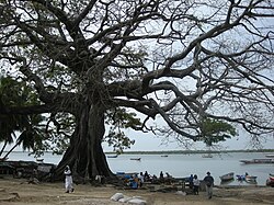 A large kapok near the pier | |
 Elinkine | |
| Coordinates: 12°30′21″N 16°39′58″W / 12.50583°N 16.66611°WCoordinates: 12°30′21″N 16°39′58″W / 12.50583°N 16.66611°W | |
| Country | Senegal |
| Region | Ziguinchor |
| Department | Oussouye |
| Population | |
| • Total | 339 |

Elinkine (also called Elinlin or Elinkinde) is a town in Casamance, Senegal, located at the mouth of the Casamance River, 35 kilometres (22 mi) from Oussouye.
History[]
A treaty between France and the leaders of Kagnout took place in Elinkine on March 25, 1851, resulting in the cession of the island of Carabane to France.
The well of Umar Tall was classified as a historic monument in 2003.
Administration[]


The village is part of the rural community of Mlomp, , Oussouye, Ziguinchor.
Geography[]
The nearest towns are , , Carabane, Samatit, , and Tamani.
Population[]
According to PEPAM (Water and Sanitation Program for the Millennium), there are 339 people and 47 households in Elinkine.
Economy[]
This small fishing port is a popular tourist location. This is partially because of its beach, but also because it is the embarkation point for the island of Carabane.


Bibliography[]
- Muriel Scibilia (2003). La Casamance ouvre ses cases. Tourisme au Sénégal (in French). L’Harmattan. p. 174. ISBN 2-85802-676-9.
External links[]
| Wikimedia Commons has media related to Elinkine. |
- Maps, weather and airports for Elinkine
- (in French) Elinkine on the PEPAM website
- (in French) Elinkine on the SEM website[permanent dead link]
- Populated places in Ziguinchor Region