Ella Island
Ella Ø (Danish) | |
|---|---|
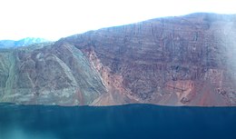 Southwestern side. Onlap of devonian sandstone (right) on folded cambrian to ordovician rocks (left). | |
 Ella Island | |
| Geography | |
| Location | Greenland Sea |
| Coordinates | 72°51′N 25°00′W / 72.850°N 25.000°WCoordinates: 72°51′N 25°00′W / 72.850°N 25.000°W |
| Administration | |
Greenland | |
| Zone | Northeast Greenland National Park |
| Demographics | |
| Population | 0 |
Ella Island, or Ella Ø, is an island in eastern Greenland, within Northeast Greenland National Park.
Geography[]
Ella Island is located at the mouth of Kempe Fjord in the northern end of King Oscar Fjord. To the east lie larger Traill Island and Geographical Society Island. Off its northern end lie and .[1]
The island has an area of 143.6 km2 and a shoreline of 59.6 kilometres.[2] Ella Island is separated from the western shore of the fjord by the .

History[]
Lauge Koch had a cabin on the northern side of the island named Eagle's nest. The botanist Thorvald Sørensen spent the years 1931-1935 here. His observations formed the basis for his doctoral thesis in 1941.
During World War II, US forces had an installation on the island called Bluie East Four.[3] The Sirius Sledge Patrol maintains a small base on the island which is manned only in summer.[4][5]
In 1971 a meteorite was found on Ella Island,[6] classified as a L-6 chondrite.
See also[]
References[]
- ^ "Kempes Fjord". Mapcarta. Retrieved 5 August 2019.
- ^ UNEP
- ^ Greenland Stations Archived 2007-11-23 at the Wayback Machine
- ^ Palle Norrit. "The Sirius Sledge Patrol". Archived from the original on 2011-04-21. Retrieved 2010-07-26.
- ^ "Organisation" (in Danish). Grønlands Kommando. Archived from the original on 2010-11-14. Retrieved 2010-07-26.
- ^ 1975Metic..10 1C Page 1
Weblinks[]
- Photograph of Sirius summer station
- Map of Ella Island showing location of station
Abandoned sites in Greenland | ||||||||||||||
|---|---|---|---|---|---|---|---|---|---|---|---|---|---|---|
|
|  | ||||||||||||
|
| |||||||||||||
|
| |||||||||||||
| ||||||||||||||
|
| |||||||||||||
| Polar exploration | ||||||||||||||
| Paleo-Eskimo | ||||||||||||||
This Greenland location article is a stub. You can help Wikipedia by . |
- Uninhabited islands of Greenland
- Greenland geography stubs