Elm Point, Minnesota

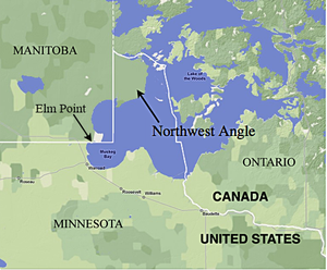
Elm Point, Minnesota, in Lake of the Woods County, Minnesota, is a small uninhabited[1] cape and a United States practical exclave, southwest of the Northwest Angle,[2] near the Indian/First Nation community of Buffalo Point. It borders Canada's province of Manitoba at the 49th parallel, and there is a line of felled trees along the 49th parallel marking the international border.[3] The cape is separated from the rest of the continental United States by the Lake of the Woods.
In addition to Elm Point, there are a few small parcels of land including Buffalo Bay Point that extend about 100 metres (300 ft) south of the 49th parallel, west of Elm Point but east of the contiguous land mass of Minnesota, which would therefore be U.S. territory.[1]
See also[]
- Northwest Angle
- Point Roberts, Washington
- Alburgh, Vermont
- Province Island
- Hyder, Alaska
Notes[]
- ^ a b Frank Jacobs (31 May 2011). "516 – Northwest Angles: One Exclave May Hide Another". Big Think. Archived from the original on 2020-11-12.
- ^ "Elm Point, Minnesota". Geographic Names Information System. United States Geological Survey.
- ^ "Google Maps".
Coordinates: 48°59′45″N 095°17′24″W / 48.99583°N 95.29000°W

- Canada–United States border
- Exclaves in the United States
- Geography of Minnesota
- Geography of Lake of the Woods County, Minnesota
- Border irregularities of the United States
- Borders of Minnesota
- Headlands of the United States
- Landforms of Lake of the Woods County, Minnesota
- Minnesota geography stubs