Elmdon
This article needs to be updated. (November 2017) |
- See also, Elmdon, West Midlands.
| Elmdon | |
|---|---|
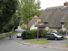 Elmdon village | |
 Elmdon Location within Essex | |
| Population | 610 (2011 Census)[1] |
| OS grid reference | TL465395 |
| District | |
| Shire county | |
| Region | |
| Country | England |
| Sovereign state | United Kingdom |
| Post town | SAFFRON WALDEN |
| Postcode district | CB11 |
| Dialling code | 01763 |
| Police | Essex |
| Fire | Essex |
| Ambulance | East of England |
| UK Parliament | |

Elmdon is a village in the Uttlesford district of Essex, England, near the boundary with Cambridgeshire and Hertfordshire. The hilly topography of the area differentiates it from countryside to the north, which is predominantly fenland and flat.
History[]
The castle motte at Elmdon, known as 'castle hill', still exists. It was the Norman fortification of Robert de Lucy, brother to Richard de Lucy, Justiciar to King Stephen and Henry II. The church at Elmdon was granted by Robert de Lucy to Lesnes Abbey (founded by Richard de Lucy), around 1180.[citation needed] One mile to the west, at the highest point in Essex, Eustace de Boulogne (d1125) built and occupied his moated house named 'Flanders' at Chrishall and it was there that his daughter Matilda of Boulogne (c1103-1152), the future wife of King Stephen, was raised.
The name Elmdon means 'hill of elms'.[citation needed] Elmdon includes a village hall, a church, and a recreation ground used for cricket and football.
Transport[]
Elmdon has an infrequent bus service with links to Bishop's Stortford. There are three roads out of Elmdon; two are minor roads leading to other villages, and the third provides access indirectly to the nearest station, Audley End on the West Anglia Main Line.
Utilities[]
Elmdon is not served by mains gas; houses rely on individually supplied heating oil systems. The village is connected to British Telecom's backbone network through the Chrishall exchange which is ADSL-enabled. As of January 2007, speeds of up to 2mb ADSL and 3mb ADSL-MAX were available through broadband over copper phone cable. No cable television providers service the village.
This article needs to be updated. (November 2017) |
Leisure[]
Elmdon has sporting teams participating in local leagues. The village is a starting point for cross country running with trails of between 3 km and 30 km, some avoiding major roads. Tracks are passable on foot and bicycle between March and November, becoming waterlogged outside this range (passable but not to run on).[original research?]
The Icknield Way Path passes through the village on its 180-kilometre (110 mi) journey from Ivinghoe Beacon in Buckinghamshire to Knettishall Heath in Suffolk. The multi-user route is open for walkers, horse riders and off-road cyclists.
See also[]
References[]
- ^ "Parish population 2011". Retrieved 28 September 2015.
- 1922-, Robin, Jean (1980). Elmdon : continuity and change in a North-West Essex village, 1861-1964. Cambridge: Cambridge University Press. ISBN 9780521228206. OCLC 5051677.CS1 maint: numeric names: authors list (link)
- Marilyn., Strathern (1981). Kinship at the core : an anthropology of Elmdon a village in north-west Essex in the nineteen-sixties. Cambridge: Cambridge University Press. ISBN 9780521105033. OCLC 7594522.
External links[]
| Wikimedia Commons has media related to Elmdon. |
- Elmdon village history
- Elmdon Parish Church Picture taken by Ian Rose in 1999
- The Icknield Way Parish (includes Elmdon)
- The Elmdon Dial sundial
- Elmdon Village Website
| Unitary authorities | |
|---|---|
| Boroughs or districts | |
| Major settlements |
|
| Rivers |
|
| Topics | |
| |
| Authority control |
|
|---|
- Villages in Essex
- Uttlesford