Eltham, New Zealand
Eltham | |
|---|---|
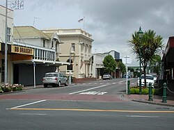 The town centre of Eltham | |
 | |
| Coordinates: 39°25′47″S 174°17′57″E / 39.42972°S 174.29917°E | |
| Country | New Zealand |
| Region | Taranaki |
| District | South Taranaki District |
| Ward | Eltham-Kaponga |
| Area | |
| • Total | 3.41 km2 (1.32 sq mi) |
| Population (June 2020)[2] | |
| • Total | 2,040 |
| • Density | 600/km2 (1,500/sq mi) |
| Postcode | 4322 |

Eltham is a small inland town in South Taranaki, New Zealand, located 50 kilometres (31 mi) south of the city of New Plymouth and southeast of the volcanic cone of Mount Taranaki/Egmont. Stratford is 11 kilometres (6.8 mi) north, Kaponga 13 km west, and Hāwera is 19 km (12 mi) south. State Highway 3 runs through the town.[3][4]
Eltham is South Taranaki's second largest town.
Eltham is known as the cradle of the Taranaki dairy industry (the co-operative system in particular), and for being the one place in New Zealand that manufactured rennet which is important in cheesemaking.[5] It was also the first place to export butter to England.[6]
History[]
European settlement began in Eltham in the 1870s, with blocks of densely forested land being taken up mainly to the north of Mountain Road. A profusion of sawmilling companies cleared the district which, when grassed, proved ideal for dairy farming.[7] In 1884, the year Eltham was declared a town district, settlers, mainly from England, arrived there and the town had a population of 25. Eltham was declared a borough in 1901, and became part of South Taranaki District with the local body amalgamations of 1989.
High Street (which runs through the centre of town - as part of State Highway 3 connecting Stratford, Ngaere, Normanby and Hāwera) and Bridge Street (which heads westward towards Kaponga and joins State Highway 45 near Opunake), were the first tar-sealed roads in New Zealand.[8][9]
Geography[]
Rivers and lakes[]

The two main watercourses which run through Eltham itself are the Mangawharawhara Stream, and the Waingongoro River.
The Mangawharawhara Stream runs to the east of the Main Trunk railway line, flows under the central business district via a culvert, and on past Eltham School and the Eltham Golf Club to the south of the town.
The Waingongoro River forms a western boundary to the town itself, flowing through the Presbyterian Church campsite (in the town's northwest) and Taumata Park (the town's main camping area and sports ground - in the western part of the town) and winding itself southwestward to meet the Tasman Sea at Ohawe Beach, near Hāwera.[10]
Eltham is also the gateway to Lake Rotokare, a scenic, natural lake surrounded by native bush (to the east of the town), and to the man-made Lake Rotorangi.
Demographics[]
| Year | Pop. | ±% p.a. |
|---|---|---|
| 2006 | 1,899 | — |
| 2013 | 1,854 | −0.34% |
| 2018 | 1,935 | +0.86% |
| Source: [11] | ||
Eltham, which covers 3.41 km2 (1.32 sq mi),[1] had a population of 1,935 at the 2018 New Zealand census, an increase of 81 people (4.4%) since the 2013 census, and an increase of 36 people (1.9%) since the 2006 census. There were 801 households. There were 984 males and 951 females, giving a sex ratio of 1.03 males per female. The median age was 39.7 years (compared with 37.4 years nationally), with 423 people (21.9%) aged under 15 years, 315 (16.3%) aged 15 to 29, 870 (45.0%) aged 30 to 64, and 321 (16.6%) aged 65 or older.
Ethnicities were 79.4% European/Pākehā, 30.2% Māori, 3.4% Pacific peoples, 3.7% Asian, and 1.9% other ethnicities (totals add to more than 100% since people could identify with multiple ethnicities).
The proportion of people born overseas was 8.4%, compared with 27.1% nationally.
Although some people objected to giving their religion, 53.5% had no religion, 30.1% were Christian, 0.2% were Hindu, 0.9% were Muslim, 0.3% were Buddhist and 5.0% had other religions.
Of those at least 15 years old, 102 (6.7%) people had a bachelor or higher degree, and 510 (33.7%) people had no formal qualifications. The median income was $24,400, compared with $31,800 nationally. The employment status of those at least 15 was that 684 (45.2%) people were employed full-time, 189 (12.5%) were part-time, and 90 (6.0%) were unemployed.[11]
Local administration[]

Eltham and the surrounding community enjoys a full library and council service (coming under the aegis of the South Taranaki District Council, based in Hāwera). Services provided include being able to register your dog, pay your rates or inquire about obtaining a building permit. The LibraryPlus is also a NZ Post agency. Other services include a Tot Time for the under 5s and regular ‘coffee and blog’ meetings for locals to learn about new technologies in a friendly environment. The LibraryPlus also has three APN computers, offering free internet and Skype to the public.
Industry[]
The town's main industry is cheese production, with much of Mainland Cheese's speciality range such as feta and camembert being produced in the Bridge Street factory.
Other cheese products such as the processed cheese used in many burgers are produced at the company's Collingwood Street site, formerly occupied by the Taranaki Co-operative Dairy Company's milk powder plant, but now extensively remodelled.[12]
Cheese has been used as a central symbol of the town, and to reinforce this view, the town's water supply tank was painted to represent a large block of cheese in 2002.
Eltham's other significant industry is the ANZCO ( formerly Riverlands) freezing works, which has a satellite plant in Bulls, in Manawatu. Both plants can process up to 1250 head of cattle daily.
Education[]
Eltham School is a coeducational full primary school (years 1-8), with a roll of 138 as of March 2021.[13][14] The school was founded in 1886.[15]
Notable people[]
- Amyas Connell (1901–1980), architect
- Martin Donnelly (1917–1999), cricketer and rugby union player
- Gavin Hill (born 1965), rugby union and rugby league player
- Charles Knight aka Tankboy (born 1967), television producer[citation needed]
- Brian Muller (1942–2019), rugby union player[16]
- Geoff Old (born 1956), rugby union player[17]
- Bryce Robins (born 1980), rugby union player[18]
- Ronald Syme (1903–1989), historian and classicist[19]
- Walter Symes (1852–1914), politician
- Chau Tseung (or Chew Chong) (1828–1920), founder of the factory system of butter manufacture in the late 1880s[20][21]
- Roger Urbahn (1934–1984), rugby union player[22]
References[]
- ^ Jump up to: a b "ArcGIS Web Application". statsnz.maps.arcgis.com. Retrieved 3 March 2021.
- ^ "Population estimate tables - NZ.Stat". Statistics New Zealand. Retrieved 22 October 2020.
- ^ Peter Dowling (editor) (2004), Reed New Zealand Atlas, Reed Books, map 34, ISBN 0-7900-0952-8CS1 maint: extra text: authors list (link).
- ^ Roger Smith, GeographX (2005), The Geographic Atlas of New Zealand, Robbie Burton, map 97, ISBN 1-877333-20-4.
- ^ See The New Zealand Co-operative Rennet Company Limited, Eltham, 50th jubilee, 1916-1966, Hawera, [N.Z.]: n.p., 1966
- ^ "Eltham Travel Guide". Jasons Travel Media.
- ^ See Davis, Brian Newton; Dollimore, Edward Stewart. "'ELTHAM.' From An Encyclopaedia of New Zealand, edited by A. H. McLintock, originally published in 1966. Te Ara - The Encyclopaedia of New Zealand, updated 18-Sep-2007". Retrieved 5 January 2008.
- ^ Andrews, Henry J. (1959), The history of Eltham, New Zealand: cradle of the dairy export industry, Eltham, [N.Z.]: Eltham Borough Council
- ^ Standish, Russell (1984), Eltham: one hundred years, Eltham, [N.Z.]: Eltham District Centennial Committee
- ^ Roth, Herbert Otto. "'CHONG, Chew.' From An Encyclopaedia of New Zealand, edited by A. H. McLintock, originally published in 1966. Te Ara - The Encyclopaedia of New Zealand, updated 18-Sep-2007". Retrieved 30 December 2007. Roth notes that it was on the banks of this river that Chew Chong set up his "Jubilee" factory in 1887.
- ^ Jump up to: a b "Statistical area 1 dataset for 2018 Census". Statistics New Zealand. March 2020. Eltham (221000). 2018 Census place summary: Eltham
- ^ The Taranaki co-operative was formed in 1965 when the Cardiff, Eltham, Normanby, and Stratford dairy co-operatives were merged. The Eltham plant was opened for the 1965-66 season. Some of the records of this company (from 1950-1983) are held at the "Dairy Records Archive, Massey University Library". Archived from the original on 29 December 2007. Retrieved 9 January 2008., and a summary of that holding may be seen at "Taranaki Co-operative Dairy Co. Ltd. (B795)". Retrieved 10 January 2008.
- ^ "New Zealand Schools Directory". New Zealand Ministry of Education. Retrieved 27 April 2021.
- ^ Education Counts: Eltham School
- ^ Carncross, Claude (1961), Eltham Public School, 1886-1961: souvenir booklet, 75th jubilee, Easter 1961, Eltham Public School Jubilee Committee / Eltham Argus
- ^ Brian Muller at AllBlacks.com
- ^ Geoff Old at AllBlacks.com
- ^ Bryce Robins at AllBlacks.com
- ^ Bruce, David. "'Ronald Syme: Taranaki's Forgotten Son.'". Archived from the original on 11 November 2007. Retrieved 31 December 2007. Brief biography from the Taranaki Daily News 14 June 2003, centennial year of his birth.
- ^ Roth, Herbert Otto. "'CHONG, Chew.' From An Encyclopaedia of New Zealand, edited by A. H. McLintock, originally published in 1966. Te Ara - The Encyclopaedia of New Zealand, updated 18-Sep-2007". Retrieved 30 December 2007. Roth notes that the establishment of the Eltham Co-operative Dairy Company in 1892 marked the "beginning of the end" for Chew Chong's pioneering dairy empire: because the co-operative could afford to pay its suppliers better. Also see the co-operative's jubilee history noted under Business History in the "Further Reading" section."
- ^ Ng, James. "'Chew Chong 1827-1844? - 1920.' Dictionary of New Zealand Biography, updated 22 June 2007". Retrieved 30 December 2007.
- ^ Roger Urbahn at AllBlacks.com
External links[]
- South Taranaki District
- Populated places in Taranaki