Emirgan
Emirgan | |
|---|---|
Neighborhood | |
 Emirgan seen from the Bosphorus. | |
 Emirgan | |
| Coordinates: 41°06′11″N 29°03′20″E / 41.10306°N 29.05556°ECoordinates: 41°06′11″N 29°03′20″E / 41.10306°N 29.05556°E | |
| Country | |
| Region | Marmara |
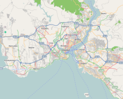
| Province | Istanbul |
| District | Sarıyer |
| Time zone | UTC+2 (EET) |
| • Summer (DST) | UTC+3 (EEST) |
| Postal code | 34467 |
| Area code | 0–212 |

Emirgan is a neighborhood of the Sarıyer district on the European side of Istanbul, Turkey. It is a historic place on the western coast of Bosphorus strait, north of the Fatih Sultan Mehmet Bridge.
Visitor attractions in Emirgan are Emirgan Park,[1] Sakıp Sabancı Museum,[2] and Emirgan Mosque.[3] Tea gardens on the coastal street along the Bosphorus are very popular in Emirgan.[3][4]
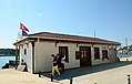
City bus lines #22, #22RE, #25E, #40T and #42T stop in Emirgan.[5] City passenger ferryboats running between Çengelköy and İstinye serve Emirgan at its pier.[6][7]
Gallery[]

A view from Emirgan Park
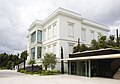
Main building of Sakıp Sabancı Museum

Historic wooden house in Emirgan

Historic wooden house in Emirgan


References[]
- ^ "İBB'den 'Emirgan' açıklaması". Hürriyet (in Turkish). 2015-02-01. Retrieved 2016-07-30.
- ^ "Sabancı'nın Atlı Köşk'ü artık müze". Hürriyet (in Turkish). 2002-06-09. Retrieved 2016-07-30.
- ^ a b "Cumhurbaşkanı Gül'ün Emirgan'da çay keyfi". Hürriyet (in Turkish). 2013-05-03. Retrieved 2016-07-30.
- ^ "En iyi 10 çay bahçesi". Hürriyet (in Turkish). 2012-04-14. Retrieved 2016-07-30.
- ^ "Durak Bilgisi: Emirgan, Sarıyer" (in Turkish). İETT. Retrieved 2016-07-30.
- ^ "Emirgan (Avrupa Yakası)" (in Turkish). Şehir Hatları. Retrieved 2016-07-30.
- ^ "Çengelköy - İstinye" (in Turkish). Şehir Hatları. Retrieved 2016-07-30.
| Beşiktaş | |
|---|---|
| Sarıyer | |
| |
| Wikimedia Commons has media related to Emirgan, Sarıyer. |
This geographical article about a location in Istanbul Province, Turkey is a stub. You can help Wikipedia by . |
- Neighbourhoods of Sarıyer
- Bosphorus
- Istanbul Province geography stubs