Emmerthal
show This article may be expanded with text translated from the corresponding article in German. (June 2015) Click [show] for important translation instructions. |
Emmerthal | |
|---|---|
 Coat of arms | |
show Location of Emmerthal within Hameln-Pyrmont district | |
 Emmerthal | |
| Coordinates: 52°3′N 9°23′E / 52.050°N 9.383°ECoordinates: 52°3′N 9°23′E / 52.050°N 9.383°E | |
| Country | Germany |
| State | Lower Saxony |
| District | Hameln-Pyrmont |
| Government | |
| • Mayor | Andreas Grossmann |
| Area | |
| • Total | 115 km2 (44 sq mi) |
| Elevation | 69 m (226 ft) |
| Population (2020-12-31)[1] | |
| • Total | 9,793 |
| • Density | 85/km2 (220/sq mi) |
| Time zone | UTC+01:00 (CET) |
| • Summer (DST) | UTC+02:00 (CEST) |
| Postal codes | 31860 |
| Dialling codes | 05155, 05157, 05286, 05151 |
| Vehicle registration | HM |
| Website | www.emmerthal.de |
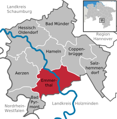


Emmerthal is a municipality in the Hameln-Pyrmont district, in Lower Saxony, Germany. It is situated on the river Weser, approximatively 6 km south of Hameln. Its seat is in the village Kirchohsen.
In 1973, the Emmerthal was formed by merging the previously independent municipalities of Amelgatzen, Bessinghausen, Börry, Brockensen, Emmern, Esperde, Frenke, Grohnde, Hagenohsen, Hajen, Hämelschenburg, Kirchohsen, Latferde, Lüntorf, Ohr, Voremberg, Welsede.
The Grohnde Nuclear Power Plant is located in the Emmerthal.
From 1933 to 1937, a field on the nearby hill of the Bückeberg was the place where the national socialists celebrated the national thanksgiving festival.
References[]
| show Towns and municipalities in Hameln-Pyrmont (district) |
|---|
| show Authority control |
|---|
This Hamelin-Pyrmont location article is a stub. You can help Wikipedia by . |
- Municipalities in Lower Saxony
- Hameln-Pyrmont
- Hanover region geography stubs