Enns (river)
| Enns | |
|---|---|
 | |
 | |
| Location | |
| Country | Austria |
| Physical characteristics | |
| Source | |
| • location | Radstädter Tauern (mountains) |
| Mouth | |
• location | Danube at Mauthausen |
• coordinates | 48°14′13″N 14°31′08″E / 48.2369°N 14.5190°ECoordinates: 48°14′13″N 14°31′08″E / 48.2369°N 14.5190°E |
| Length | 253.4 km (157.5 mi) [1] |
| Basin size | 6,000 km2 (2,300 sq mi) |
| Discharge | |
| • average | 201 m3/s (7,100 cu ft/s) |
| Basin features | |
| Progression | Danube→ Black Sea |

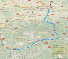
The Enns is a southern tributary of the river Danube, joining northward at Enns, Austria. The Enns River spans 253 kilometres (157 mi), in a flat-J-shape.[2] It flows from its source near the village Flachau, generally eastward through Radstadt, Schladming, and Liezen, then turns north near Hieflau, to flow past Weyer and Ternberg through Steyr, and further north to the Danube at Enns (see map in References).[2]
Geography[]
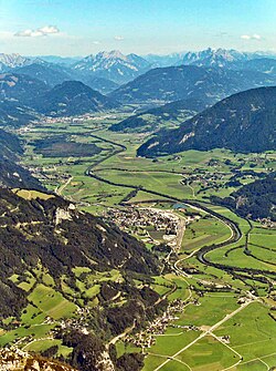
The Enns has its source in the Radstädter Tauern mountains in the Austrian state of Salzburg. In a valley which developed during the ice age, it flows at the border between the Northern Limestone Alps and the Central Eastern Alps on an eastern trajectory through Styria, where it passes the Dachstein group at its southern side. Between Admont and Hieflau, it takes a turn to the North and passes through the Gesäuse, a gorge of a length of 15 km (9.3 mi), where it penetrates the limestone of the Ennstaler Alpen. Flowing to the north from there on, it reaches the state of Upper Austria at the mouth of the . North of Steyr, it forms the border between Upper Austria and Lower Austria (formerly also known as Austria above the Enns and Austria below the Enns). Finally, it meets the Danube at Mauthausen and the city of Enns.
The Enns is a typical wild water river and draws its water from an area of more than 6,000 square kilometres (2,300 sq mi), which is the fifth-largest in Austria. The average outflow at its mouth is 201 cubic metres per second (7,100 cu ft/s).
The Anisian Age in the Triassic Period of geological time is named from Anisus, the Latin name of the river Enns.
History[]
In the middle of the 19th century, canals began to be built along the 70 km (43 mi) between Weißenbach and the Gesäuse, in order to make use of the water for agriculture and forestry.
In total, ten power plants with a total generative power of 345 megawatts have been built by the Ennskraftwerke AG.
Towns along the river[]
in Salzburg[]
in Styria[]
in Upper Austria[]
- Großraming
- Ternberg
- Garsten
- Steyr
- Enns
Hydroelectric power stations[]
Currently, there are 15 hydroelectric power stations on the Enns.[3] The power stations are listed beginning at the headwaters:
| Dam | Nameplate capacity (MW) | Annual generation (Mio. kwh) |
|---|---|---|
| 2 | 6.8 | |
| 63 | 388 | |
| 25 | 135.5 | |
| 30 | 173.5 | |
| 26 | 165.9 | |
| 30 | 122.8 | |
| 37 | 159.6 | |
| 72 | 270.7 | |
| 39 | 170 | |
| 40 | 169.7 | |
| 34 | 145.5 | |
| Garsten-St. Ulrich | 38 | 162.5 |
| 43 | 203.2 | |
| 25 | 111.8 | |
| 52 | 261.6 |
Tributaries[]
The most important inflows are the , the Salza and the Steyr.
Transport[]
A major transit route connecting Germany and Slovenia through Austria runs through the Enns valley. The so-called Eisenstraße ("iron road") runs along the river between Hieflau and Enns, along which iron ore has been transported from the Styrian Erzberg ("ore mountain") to the steel mill in Linz.
References[]
- ^ Digitaler Atlas der Steiermark (Styria)
- ^ Jump up to: a b "Karte-Enns" (river map in German), RadTouren.at (Austria), May 2009, webpage: RT-map at the Wayback Machine (archive index) (236kb).
- ^ "Die Enns" (in German). Verbund. Retrieved 2016-09-14.
| hide Authority control | |
|---|---|
| General | |
| National libraries | |
- Tributaries of the Danube
- Rivers of Salzburg (state)
- Rivers of Styria
- Rivers of Upper Austria
- Ennstal Alps
- Enns basin
- Rivers of Austria