Ensenada, Guánica, Puerto Rico
Ensenada | |
|---|---|
Barrio | |
 Seventh-day Adventist Church in Ensenada | |
 Location of Ensenada within the municipality of Guánica shown in red | |
 Ensenada Location of Puerto Rico | |
| Coordinates: 17°58′06″N 66°55′45″W / 17.968376°N 66.929167°WCoordinates: 17°58′06″N 66°55′45″W / 17.968376°N 66.929167°W[1] | |
| Commonwealth | |
| Municipality | |
| Area | |
| • Total | 1.04 sq mi (2.7 km2) |
| • Land | 0.79 sq mi (2.0 km2) |
| • Water | 0.25 sq mi (0.6 km2) |
| Elevation | 7 ft (2 m) |
| Population (2010) | |
| • Total | 1,705 |
| • Density | 2,158.2/sq mi (833.3/km2) |
| Source: 2010 Census | |
| Time zone | UTC−4 (AST) |
| ZIP Code | 00647 |

Ensenada Barrio is a barrio in the municipality of Guánica, Puerto Rico. Its population in 2010 was 1,705.[3][4][5][6]
| Historical population | |||
|---|---|---|---|
| Census | Pop. | %± | |
| 1930 | 4,205 | — | |
| 1940 | 4,829 | 14.8% | |
| 1950 | 4,730 | −2.1% | |
| 1980 | 1,982 | — | |
| 1990 | 2,108 | 6.4% | |
| 2000 | 2,184 | 3.6% | |
| 2010 | 1,705 | −21.9% | |
| U.S. Decennial Census[7] 1899 (shown as 1900)[8] 1910-1930[9] 1930-1950[10] 1980-2000[11] 2010[12] | |||
Gallery[]

Sign for Manglillo Beach in Guánica

Women wading near mangroves in Manglillo Beach
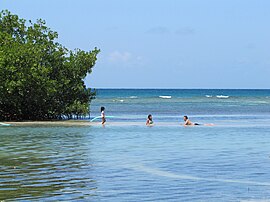
On a sandbar in Manglillo Beach

See also[]
References[]
- ^ Jump up to: a b "US Gazetteer 2019". US Census. US Government.
- ^ U.S. Geological Survey Geographic Names Information System: Ensenada barrio
- ^ Picó, Rafael; Buitrago de Santiago, Zayda; Berrios, Hector H. Nueva geografía de Puerto Rico: física, económica, y social, por Rafael Picó. Con la colaboración de Zayda Buitrago de Santiago y Héctor H. Berrios. San Juan Editorial Universitaria, Universidad de Puerto Rico,1969.
- ^ Gwillim Law (20 May 2015). Administrative Subdivisions of Countries: A Comprehensive World Reference, 1900 through 1998. McFarland. p. 300. ISBN 978-1-4766-0447-3. Retrieved 25 December 2018.
- ^ Puerto Rico:2010:population and housing unit counts.pdf (PDF). U.S. Dept. of Commerce, Economics and Statistics Administration, U.S. Census Bureau. 2010.
- ^ Mapa de Municipios y Barrios (PDF). Santurce, Puerto Rico: Junta de Planificación. 1955. p. 25. Retrieved 10 April 2021.
- ^ "U.S. Decennial Census". United States Census Bureau. Archived from the original on February 13, 2020. Retrieved September 21, 2017.
- ^ "Report of the Census of Porto Rico 1899". War Department Office Director Census of Porto Rico. Archived from the original on July 16, 2017. Retrieved September 21, 2017.
- ^ "Table 3-Population of Municipalities: 1930 1920 and 1910" (PDF). United States Census Bureau. Archived (PDF) from the original on August 17, 2017. Retrieved September 21, 2017.
- ^ "Table 4-Area and Population of Municipalities Urban and Rural: 1930 to 1950" (PDF). United States Census Bureau. Archived (PDF) from the original on August 30, 2015. Retrieved September 21, 2014.
- ^ "Table 2 Population and Housing Units: 1960 to 2000" (PDF). United States Census Bureau. Archived (PDF) from the original on July 24, 2017. Retrieved September 21, 2017.
- ^ Puerto Rico:2010:population and housing unit counts.pdf (PDF). U.S. Dept. of Commerce Economics and Statistics Administration U.S. Census Bureau. 2010. Archived (PDF) from the original on 2017-02-20. Retrieved 2019-08-02.
External links[]
| hide Authority control | |
|---|---|
| General |
|
| National libraries | |
This Guánica, Puerto Rico location article is a stub. You can help Wikipedia by . |
Categories:
- Barrios of Guánica, Puerto Rico
- Puerto Rico Senatorial district V geography stubs