Erlauf (river)
| Erlauf | |
|---|---|
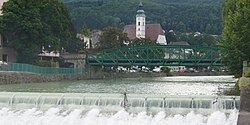 The Erlauf at Scheibbs | |
| Location | |
| Country | Austria |
| States | Lower Austria and Styria |
| Physical characteristics | |
| Source | |
| • location | at the foot of the |
| • coordinates | 47°48′27″N 15°13′48″E / 47.8076°N 15.2299°E |
| Mouth | |
• location | at Pöchlarn into the Danube |
• coordinates | 48°12′48″N 15°11′39″E / 48.2134°N 15.1943°ECoordinates: 48°12′48″N 15°11′39″E / 48.2134°N 15.1943°E |
| Basin features | |
| Progression | Danube→ Black Sea |

Erlauf is a river of Lower Austria and of Styria, Austria.[1]
The Erlauf springs at the foot of the mountain [1][2] It is a right tributary of the Danube in Pöchlarn.[3]
References[]
| Wikimedia Commons has media related to Erlauf (river). |
- ^ Jump up to: a b "Erlauf source and Gemeindealpe". Niederösterreich ATLAS. Retrieved 22 January 2020. (look for Erlaufursprung)
- ^ Google (20 January 2020). "Erlach source" (Map). Google Maps. Google. Retrieved 20 January 2020.
- ^ Google (20 January 2020). "Erlauf mouth" (Map). Google Maps. Google. Retrieved 20 January 2020.
| Authority control |
|
|---|
This Styria location article is a stub. You can help Wikipedia by . |
This Lower Austria location article is a stub. You can help Wikipedia by . |
Categories:
- Tributaries of the Danube
- Rivers of Lower Austria
- Rivers of Styria
- Rivers of Austria
- Styria geography stubs
- Lower Austria geography stubs
- Austria river stubs