Espot
Espot | |
|---|---|
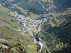
 Aerial view of Espot | |
 Location in Pallars Sobirà | |
| Coordinates: 42°34′43″N 1°5′17″E / 42.57861°N 1.08806°ECoordinates: 42°34′43″N 1°5′17″E / 42.57861°N 1.08806°E | |
| Country | |
| Community | |
| Province | Lleida |
| Comarca | Pallars Sobirà |
| Government | |
| • Mayor | Josep Maria Sebastià Canal (2015)[1] |
| Area | |
| • Total | 97.3 km2 (37.6 sq mi) |
| Elevation | 1,318 m (4,324 ft) |
| Population (2018)[3] | |
| • Total | 352 |
| • Density | 3.6/km2 (9.4/sq mi) |
| Website | espot |
Espot is a municipality in the comarca of the Pallars Sobirà in Catalonia, Spain. It is located in the Espot Valley, east of the river Noguera Pallaresa. The municipality is one of the entrances to the Aigüestortes i Estany de Sant Maurici National Park. Espot has been mentioned in documents dating back to the year 839.
Economy[]
The economy of the municipality is largely based on tourism, thanks to the ski resort Espot Esquí and an increase in rural tourism. The area also depends on the milk industry and cattle ranching, specifically bovines. There are various hydroelectric power stations in the area including Sant Maurici, Lladres and Espot.
Population history[]
| 1900 | 1930 | 1950 | 1970 | 1981 | 1986 | 2008 |
|---|---|---|---|---|---|---|
| 310 | 313 | 607 | 269 | 227 | 224 | 360 |
References[]
- ^ "Ajuntament d'Espot". Generalitat of Catalonia. Retrieved 2015-11-13.
- ^ "El municipi en xifres: Espot". Statistical Institute of Catalonia. Retrieved 2015-11-23.
- ^ Municipal Register of Spain 2018. National Statistics Institute.
- Espot" (in Catalan) from the Enciclopèdia Catalana
- Tomàs Bonell, Jordi; Descobrir Catalunya, poble a poble, Prensa Catalana, Barcelona, 1994
External links[]
| Wikimedia Commons has media related to Espot. |
- Espot City Council (in Catalan)
- Government data pages (in Catalan)
- Information and images of Espot (in Spanish)
Categories:
- Municipalities in Pallars Sobirà
- Populated places in Pallars Sobirà
- Province of Lleida geography stubs
