Essen (Oldenburg)
Essen (Oldenburg) | |
|---|---|
 Flag  Coat of arms | |
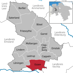
show Location of Essen (Oldenburg) within Cloppenburg district | |
 Essen (Oldenburg) | |
| Coordinates: 52°43′16″N 7°56′26″E / 52.72111°N 7.94056°ECoordinates: 52°43′16″N 7°56′26″E / 52.72111°N 7.94056°E | |
| Country | Germany |
| State | Lower Saxony |
| District | Cloppenburg |
| Subdivisions | 14 Ortsteile |
| Government | |
| • Mayor | Heiner Kreßmann |
| Area | |
| • Total | 97.97 km2 (37.83 sq mi) |
| Elevation | 26.10 m (85.63 ft) |
| Population (2020-12-31)[1] | |
| • Total | 9,100 |
| • Density | 93/km2 (240/sq mi) |
| Time zone | UTC+01:00 (CET) |
| • Summer (DST) | UTC+02:00 (CEST) |
| Postal codes | 49632 |
| Dialling codes | 05434, 05438 |
| Vehicle registration | CLP |
| Website | essen-oldb.de |


Essen (Oldenburg) is a municipality in the district of Cloppenburg, in Lower Saxony, Germany. It is on the river Hase, about 5 kilometres (3.1 mi) north of Quakenbrück and 15 kilometres (9.3 mi) southwest of Cloppenburg.

Essen consists of the following villages: Addrup, Ahausen, Barlage, Bartmannsholte, Beverdiek, Bevern, Bokel, Brokstreek, Calhorn, Darrel, Essen proper, Felde, Gut Lage, Herbergen, Hülsenmoor, Nordholte, Osteressen, Sandloh and Uptloh.
The reference to Oldenburg serves to allow disambiguation with the much larger Essen (Ruhr). It is part of the official name as stated in the town constitution, which also prescribes the styling using parentheses.[2]
| Wikimedia Commons has media related to Essen (Oldenburg). |
References[]
- ^ Landesamt für Statistik Niedersachsen, LSN-Online Regionaldatenbank, Tabelle A100001G: Fortschreibung des Bevölkerungsstandes, Stand 31. Dezember 2020.
- ^ "Änderung der Hauptsatzung der Gemeinde Essen (Oldenburg)". 16 December 2019.
Die 1. Änderungssatzung zur Änderung der Hauptsatzung entsprechend der Anlage mit der Führung des Gemeindenamens „Gemeinde Essen (Oldenburg)“, wird vom Rat einstimmig beschlossen.
| show Towns and municipalities in Cloppenburg (district) |
|---|
| show Authority control |
|---|
This Cloppenburg district location article is a stub. You can help Wikipedia by . |
- Municipalities in Lower Saxony
- Cloppenburg (district)
- Weser-Ems region geography stubs