Estabrook Park
| Estabrook Park | |
|---|---|
 | |
| Location | Shorewood, Wisconsin, United States |
| Coordinates | 43°05′54″N 87°54′17″W / 43.098293°N 87.904689°WCoordinates: 43°05′54″N 87°54′17″W / 43.098293°N 87.904689°W |
| Area | 126.25 acres (51.09 ha) |
| Created | 1916 |
| Operated by | Milwaukee County Parks Department |
| Website | https://county.milwaukee.gov/files/county/parks-department/Park-Maps/Estabrook1.pdf |

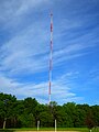
Estabrook Park is a Milwaukee County park in the village of Shorewood, Wisconsin and is home to the 1,081 ft (329 m) WITI TV Tower and the historic Benjamin Church House.[1] It was named for Charles E. Estabrook, a distinguished Wisconsin lawyer and politician,[2] and is located on a nearly 125 acre, strip of land between the Milwaukee River and the former Chicago and Northwestern Railroad, now converted into part of the Oak Leaf Trail.
Amenities[]
There are picnic areas, soccer fields, a disc golf course, a softball diamond, a dog park, a beach volleyball court, a skatepark, and the Estabrook Park Beer Garden.[3]
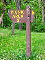
Picnic area signage

Northern playground
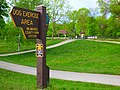
Dog park and signage

Picnic area signage and southern playground
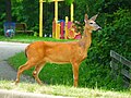
Southern playground with whitetail deer in the foreground

Soccer field signage


History[]
The riverside site was home to the Milwaukee Cement Company from 1875 to 1911.[2] The park was established in 1916, and the first parkway in the Milwaukee River Parkway system was added in 1927. Significant development took place in the early and mid-1930s, led in part by the Civilian Conservation Corps. In 1937 Milwaukee County constructed a dam at the park to raise water levels for recreational purposes.[4] A year later the Benjamin Church house was restored and moved to the park in 1938.[1] The WITI TV Tower was erected within the park in 1962. In 2018 the dam was removed.[4]

Estabrook Park Maintenance Headquarters

Historical marker
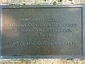
Estabrook Park Historical Plaque


Pond[]
There is a small pond, sometimes called Estabrook Park Lagoon, covering about 1 acre (0.40 ha) to a maximum depth of 6 ft (1.8 m) and with a small island near the north end.[5] It is reported to contain panfish, trout, goldfish, chinese mystery snail, and Eurasian watermilfoil.[6] There have also been sightings, depending on the season, of painted turtles, red-eared sliders, common snapping turtles, muskrats, American bullfrogs, American toads, Canada geese, mallards, wood ducks, blue-winged teals, great blue herons, green herons, red-breasted mergansers, hooded mergansers, pied-billed grebes, ring-billed gulls, and belted kingfishers in and on the water. Canada geese, mallards, and wood ducks have been observed to lay eggs, incubate them, and hatch broods of goslings and ducklings.

Estabrook Park Pond, facing west

Canada goose and goslings on shore of Estabrook Park Pond

Great Blue Heron on Estabrook Park Pond

Painted turtles and red-eared sliders sunning themselves on a log in Estabrook Park

Estabrook Park Fishing Plaquard

Estabrook Park Fishing Notice Plaquard


Beer garden[]
"Estabrook Beer Garden brought back the tradition of public beer gardens to Milwaukee."[7] "Estabrook Beer Garden is part of the Milwaukee County Park System, developed and operated under contract by ABC Estabrook INC d/b/a Estabrook Beer Garden."

Disc golf[]
There is a 20-hole disc golf course covering much of the northern end of the park.

Estabrook Park disk golf marker

Estabrook Park disc golf course pay station

Estabrook Park disc golf course target


Antennas[]
There are four broadcasting antenna in and near the park: one, free-standing tower antenna located entirely in the park at the south east corner, and three triangular lattice guyed mast antenna located just across the Milwaukee River from the park, each with a guy-wire anchor located in the park. From north to south, they are:
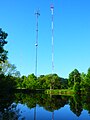
Estabrook Park pond with antenna towers across the river in the background
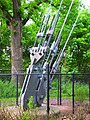
Antenna mast guy-wire anchor 1

Antenna mast guy-wire anchor 2
Soccer field with antenna tower across the river in the background
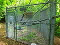
Antenna mast guy-wire anchor 3

View across soccer field of WITI TV Tower and Benjamin Church House at south end of park

WITI TV Tower detail in southeast corner of park


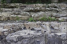
Geology[]
The park comprises a mostly flat plateau at about 650 ft (200 m) above sea level, a bluff descending about 50 ft (15 m) to the Milwaukee river at about 600 ft (180 m) above sea level, and some flat areas along the river bank. The Milwaukee Formation is exposed on the descent to the river.[8]
Gallery[]

Estabrook Park Plaque

Estabrook Park stairway down bluff to Milwaukee River
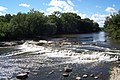
Milwaukee River along west edge of park

Estabrook Park underpass to Wilson Drive


References[]
- ^ a b "Shorewood Landmarks". Milwaukee County Historical Society. Retrieved 2017-11-06.
- ^ a b "History of Estabrook". Friends of Estabrook Park. Retrieved 2020-05-31.
- ^ "Estabrook Beer Garden". Retrieved 2020-05-31.
- ^ a b "Estabrook Dam Removal". Milwaukee Riverkeeper (in American English). Retrieved 2021-04-22.
- ^ "Estabrook Park Lagoon". Lake-Link Inc. Retrieved 2020-05-31.
- ^ "Estabrook Park Lagoon". Wisconsin Department of Natural Resources. Retrieved 2020-05-31.
- ^ "Beer Gardens". Milwaukee County. Retrieved 2020-07-17.
- ^ USGS (2018). Milwaukee, WI (Map). USGS.
External links[]
- Milwaukee Country Parks: Estabrook Park Map
- Wisconsin Department of Natural Resources: Estabrook Park Lagoon
- Friends of Estabrook Park
This article about a location in Milwaukee County, Wisconsin is a stub. You can help Wikipedia by . |
- Protected areas of Milwaukee County, Wisconsin
- Parks in Wisconsin
- Milwaukee metropolitan area geography stubs
- Civilian Conservation Corps in Wisconsin
- Removed dams in Wisconsin