Estuary of St. Lawrence
| Saint Lawrence Estuary Estuaire du Saint-Laurent (in French) | |
|---|---|
 Estuary of Saint-Laurent at Port-au-Saumon (Quebec). | |
  | |
| Etymology | Saint Lawrence of Rome |
| Location | |
| Country | Canada |
| Province | Quebec |
| Physical characteristics | |
| Source | Saint Lawrence River |
| • location | Lake Saint-Pierre, Trois-Rivières, Quebec, Canada |
| • coordinates | 46°16′17″N 72°38′5″W / 46.27139°N 72.63472°W |
| Mouth | Gulf of St. Lawrence / Atlantic Ocean |
• location | , Quebec, Canada |
• coordinates | 49°08′N 67°14′W / 49.133°N 67.233°WCoordinates: 49°08′N 67°14′W / 49.133°N 67.233°W |
• elevation | 0 m (0 ft) |
| Discharge | |
| • location | below the Saint Lawrence River |
The estuary of the Saint Lawrence in Quebec, Canada, is the largest estuary in the world.[1]
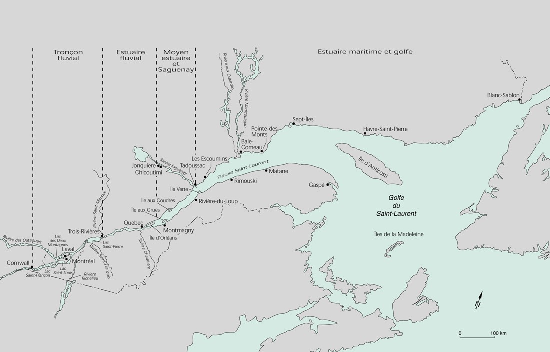
Situation[]
The estuary of the St. Lawrence River is located downstream of the St. Lawrence River and upstream of the Gulf of St. Lawrence. It refers to the place where the fresh and salt waters mix between the river and the gulf. The St. Lawrence Estuary begins at Lake Saint-Pierre[2] and ends at the widening of the shores, at the height of ,[3] opposite Les Méchins, Quebec. It is divided into three sections: the St. Lawrence River estuary at Île d'Orléans (Orleans Island), the middle estuary to the Saguenay Fjord, the maritime estuary to Pointe-des-Monts, Quebec.
The St. Lawrence Estuary is characterized by a saline front at the eastern tip of Île d'Orléans. The zone of contact between fresh and salt water corresponds to a region of high concentrations of suspended matter causing a zone of maximum turbidity (MTZ) of a length that can vary from 70 to 120 kilometres (43 to 75 mi), depending on the flow of the river.[4] This zone of maximum turbidity is located between Île d'Orléans (salinity greater than 0 PSU) and Île aux Coudres (salinity below 10 PSU). The mechanisms of estuarine circulation associated with this environment make it a privileged site of primary and secondary production which shelters many fish nurseries. High environmental turbidity provides shelter against predators while larvae are maintained under optimum temperature and salinity conditions.[5][6][7] Large variations in salinity and turbidity result in a wide variety of physicochemical conditions and planktonic communities on the river.
Fauna and flora[]
An emblematic species is the beluga (beluga whale), but many other species are present.
In a spirit of citizen science and collaborative work, a census of estuary fish is underway, with a downloadable identification guide[8]
See also[]
 Canada portal
 Rivers portal
Notes[]
- ^ Rossignol, Anne (1998). L’estuaire maritime et le golfe du Saint-Laurent: Carnet d’océanographie (in French). Rimouski: INRS-Oceanology & Pêches et Océans Canada. p. 12. ISBN 2-9805922-0-X.
L’estuaire du Saint-Laurent se classe parmi les plus profond et les plus grands estuaires du monde; sa largeur excède même la longueur de plusieurs estuaires.
- ^ "0303-carte.jpg". Sustainable development, Environment and Park. Retrieved 27 November 2008.
- ^ "Le Gîte du Phare de Pointe-des-Monts". www.pointe-des-monts.com.
- ^ Silverberg, Norman; Sundby, Bjørn (1979-04-01). "Observations in the turbidity maximum of the St. Lawrence Estuary". Canadian Journal of Earth Sciences. 16 (4): 939–950. doi:10.1139/e79-080. ISSN 0008-4077.
- ^ Sirois, P; Dodson, Jj (2000). "Critical periods and growth-dependent survival of larvae of an estuarine fish, the rainbow smelt Osmerus mordax". Marine Ecology Progress Series. 203: 233–245. doi:10.3354/meps203233. ISSN 0171-8630.
- ^ North, E. W.; Houde, E. D. (October 2001). "Retention of White Perch and Striped Bass Larvae: Biological-Physical Interactions in Chesapeake Bay Estuarine Turbidity Maximum". Estuaries. 24 (5): 756. doi:10.2307/1352883.
- ^ Winkler, G; Dodson, Jj; Bertrand, N; Thivierge, D; Vincent, Wf (2003). "Trophic coupling across the St. Lawrence River estuarine transition zone". Marine Ecology Progress Series. 251: 59–73. doi:10.3354/meps251059. ISSN 0171-8630.
- ^ C. Nozères, D. Archambault, P.-M.Chouinard, J. Gauthier, R. Miller, E. Parent, P. Schwab, L. Savard and J.-D. Dutil, Guide to the Identification of Marine Fish in the Estuary and Northern Gulf of St. Lawrence and Protocols for Their sampling during trawl surveys between 2004 and 2008, Regional Directorate of Science; Fisheries and Oceans Canada, Heavy Document (over 86 Mb)
- Estuaries of Canada
- Saint Lawrence River