Exurb
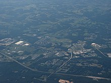

An exurb (alternately: exurban area) is an area outside the typically denser inner suburban area of a metropolitan area, which has an economic and commuting connection to the metro area, low housing density, and growth. It shapes an interface between urban and rural landscapes holding an urban nature for its functional, economic, and social interaction with the urban center, due to its dominant residential character.[1] They consist of "agglomerations of housing and jobs outside the municipal boundaries of a primary city"[2] and beyond its suburbs.[3]
Definitions[]
The word exurb (a portmanteau of extra and urban) was coined by Auguste Comte Spectorsky, in his 1955 book The Exurbanites, to describe the ring of prosperous communities beyond the suburbs that are commuter towns for an urban area.[4] In other uses the term has expanded to include popular extra-urban districts which nonetheless have poor transportation and underdeveloped economies.[5] Exurbs can be defined in terms of population density across the extended urban area, for example "the urban core (old urban areas including Siming and Huli, where the population density is greater than 51 persons per ha), the suburban zone (old urban and new urban transitional zones including Haicang and Jimei, where the population density is greater than 8 persons per ha), and the exurban areas (newly urbanized areas including Tong'an and Xiang'an, where the population density is less than 8 persons per ha)".[6] The mixture of urban and rural environments raises ecological issues.[7][6]
Exurbs by country[]
China[]
- Changping District, Beijing
- Shunyi District, Beijing
- Shenjia village, Loudi city, Hunan province[5]
Russia[]
United States[]
Since the Finding Exurbia report by the Brookings Institution in 2006, the term is generally used[citation needed] for areas beyond suburbs and specifically less densely built than the suburbs to which the exurbs' residents commute.[9] To qualify as exurban, a census tract must meet three criteria:[9]
- Economic connection to a large metropolis.
- Low housing density: bottom third of census tracts with regard to housing density. In 2000, this was a minimum of 2.6 acres (11,000 m2) per resident.
- Population growth exceeding the average for its metropolitan area.
These are based on published datasets. Alternative approaches include working with Oak Ridge National Laboratory LandScan data and GIS.[10]
Exurban areas incorporate a mix of rural development (e.g., farms and open space) and in places, suburban-style development (e.g., tracts of single-family homes, though usually on large lots). In long-settled areas, such as the U.S. Northeast megalopolis, exurban areas incorporate pre-existing towns, villages and smaller cities, as well as strips of older single-family homes built along pre-existing roads that connected the older population centers of what was once a rural area. The Brookings Institution listed exurban counties, defined as having at least 20% of their residents in exurban Census tracts:[9]
See also[]
References[]
- ^ Fra Paleo, Urbano (2004). "Exurbia". In Caves, R. W. (ed.). Encyclopedia of the City. Routledge. p. 254.
- ^ Shirgaokar, M (2014). "Employment centers and travel behavior: exploring the work commute of Mumbai's rapidly motorizing middle class". Journal of Transport Geography. 41: 249–258. doi:10.1016/j.jtrangeo.2014.10.003. "Here the term exurb is taken from the North American planning literature, and is used to designate agglomerations of housing and jobs outside the municipal boundaries of a primary city. Such exurbs may have independent municipal governance."
- ^ Duffy, A (2009). "Land use planning in Ireland – a life cycle energy analysis of recent residential development in the Greater Dublin Area". The International Journal of Life Cycle Assessment. 14 (3): 268–277. doi:10.1007/s11367-009-0059-7. S2CID 56212626. "The GDA was split into four zones each encompassing development at increasing radii from Dublin's city centre, namely: city centre, suburbs, exurbs and commuter towns."
- ^ Spectorsky, Auguste C. (1955). The Exurbanites. Lippincott, Philadelphia: J. B. Lippincott & Co. OCLC 476943.
- ^ Jump up to: a b Zhang, Ying; Chen, Zuzhan; Sun, Hongkai; Zhang, Shili; Liu, Haoqian (1 December 2019). "Study on the Utilization of Vacant Houses in Rural Exurbs Under the Background of Rural Revitalization Strategy by Taking Shenjia Village in Hunan Province as an Example". Earth and Environmental Science. IOP conference series. 371 (2): 22055.
- ^ Jump up to: a b Ren, Y., Wei, X., Wei, X., Pan, J., Xie, P., Song, X., Peng, D., & Zhao, J. (2011). "Relationship between vegetation carbon storage and urbanization: A case study of Xiamen, China". Forest Ecology and Management. 261 (7): 1214–1223. doi:10.1016/j.foreco.2010.12.038.CS1 maint: multiple names: authors list (link)
- ^ Vinzant, Carol (17 December 2007). "Dog vs. bear: release the hounds! A new weapon in the battle to keep New Jersey exurbs bear-free". New York. 40 (45): 2.
- ^ Salomatin, Konstantin. "Moscow's poshest neighborhood is shockingly empty as money pours out of Russia". business insider. insider. Retrieved 11 August 2020.
- ^ Jump up to: a b c Berube, Alan; Singer, Audrey; Wilson, Jill H.; Frey, William H. (October 2006). "Finding Exurbia: America's Fast-Growing Communities at the Metropolitan Fringe". Living Cities Census Series. Washington, D.C.: The Brookings Institution. Retrieved 2020-08-03.
We first identify exurbs using census tracts—small areas with an average of 4,000 people—and then aggregate these areas to the county level for further analysis.
- ^ Taylor, Laura (2011), "No boundaries: exurbia and the study of contemporary urban dispersion", GeoJournal, 76 (4): 323–339, doi:10.1007/s10708-009-9300-y, S2CID 128461360
- Types of towns
- Urban studies and planning terminology
- Urbanization
- Rural geography
- Public transport
- 1950s neologisms