Fântânele, Mureș
Fântânele
Gyulakuta | |
|---|---|
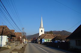 View of Viforoasa | |
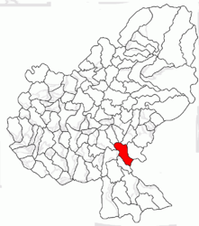 Location in Mureș County | |
 Fântânele Location in Romania | |
| Coordinates: 46°25′N 24°45′E / 46.417°N 24.750°ECoordinates: 46°25′N 24°45′E / 46.417°N 24.750°E | |
| Country | Romania |
| County | Mureș |
| Government | |
| • Mayor (2020–2024) | József Varga[1] (UDMR) |
| Area | 64.14 km2 (24.76 sq mi) |
| Population (2011)[2] | 4,693 |
| • Density | 73/km2 (190/sq mi) |
| Time zone | EET/EEST (UTC+2/+3) |
| Vehicle reg. | MS |
| Website | www |

Fântânele (Hungarian: Gyulakuta; Hungarian pronunciation: [ˈɟulɒkutɒ]) is a commune in Mureș County, Transylvania, Romania composed of six villages:
- Bordoșiu / Bordos
- Călimănești / Kelementelke
- Cibu / Csöb
- Fântânele
- Roua / Rava
- Viforoasa / Havadtő
The commune is located in the southern part of the county, 28.3 km (17.6 mi) from the county seat, Târgu Mureș, on the border with Harghita County. It lies on the right bank of the Balta River.
Demographics[]
The commune has a Székely Hungarian majority. According to the 2011 census it has a population of 4,595 of which 93.84% or 4,312 are Hungarian.

Reformed church in Fântânele

Abandoned power plant in Fântânele
| Year | 1850 | 1880 | 1900 | 1910 | 1930 | 1956 | 1977 | 1992 | 2002 | 2007 | 2011 |
|---|---|---|---|---|---|---|---|---|---|---|---|
| Population | 3,690 | 3,838 | 4,140 | 4,324 | 4,496 | 6,612 | 6,009 | 5,329 | 5,067 | 5,011[3] | 4,595[4] |
See also[]
References[]
- ^ "Results of the 2020 local elections". Central Electoral Bureau. Retrieved 10 June 2021.
- ^ "Populaţia stabilă pe judeţe, municipii, oraşe şi localităti componenete la RPL_2011" (in Romanian). National Institute of Statistics. Retrieved 4 February 2014.
- ^ "The population of the village in 2007 on the website of Romanian national Statistical Institute". Archived from the original on 7 August 2010. Retrieved 21 April 2010.
- ^ "Population of Mureș in 2011" (PDF). 2011. Archived from the original (PDF) on 26 November 2013. Retrieved 9 March 2012.

Categories:
- Communes in Mureș County
- Localities in Transylvania