Führerbau


The Führerbau – translated as "the Führer's building" – was built from 1933 to 1937 after the plans of architect Paul Ludwig Troost, at Arcisstrasse 12 in Maxvorstadt, Munich. The first plans were made in 1931. The building was completed three years after Troost's death by Leonhard Gall.
During the Nazi times, the building served as a representative building for Adolf Hitler. The Führerbau has historical significance as it was where Neville Chamberlain and Adolf Hitler signed the Munich Agreement in 1938.[1]
Architecturally, the Brienner Strasse is a symmetry axis. At the Katharina-von-Bora-Strasse 10 is a very similar building: the "Verwaltungsbau der NSDAP" (Administrative Building of the NSDAP). After the German surrender, the US occupation forces used both buildings as the "Zentrale Sammelstelle" (Central Collecting Point), which cared for the looted art stolen by Nazis all over Europe.[2]
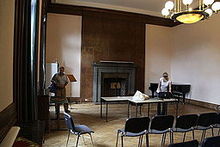
Today, the building houses the Hochschule für Musik und Theater München (University of Music and Performing Arts Munich). Its congress hall now serves as a concert venue. From 2005 to 2011 an unknown number of Stolpersteine (between 20 and 25) were installed in the building until city officials removed them for reasons of fire protection.[3]
References[]
- ^ "Echoes of 'Peace in our time'". The Irish Times. 30 September 2013. Retrieved 3 September 2021.
- ^ Lauterbach, Iris; Elliott, Fiona; Sheehan, James J. (2019). The Central Collecting Point in Munich - A New Beginning for the Restitution and Protection of Art. Getty Publications. ISBN 978-1606065822.
- ^ Rudolf Stumberger: In München darf niemand stolpern [In Munich no one is allowed to stumble], Stolpersteine zur Erinnerung an die Opfer der Nazi-Diktatur sind auf städtischen Grundstücken verboten. Neues Deutschland (Berlin), 2 December 2012, retrieved on 14 July 2017
External links[]
| Wikimedia Commons has media related to Führerbau. |
Coordinates: 48°08′46″N 11°34′04″E / 48.14611°N 11.56778°E

| Authority control |
|---|
- Buildings and structures in Munich
- Maxvorstadt
- Nazi architecture
- Buildings and structures completed in 1937
- University of Music and Performing Arts Munich