Fagradalsfjall
| Fagradalsfjall | |
|---|---|
 Fagradalsfjall with its main peak Langhóll and Geldingadalir to the right (2012 photo) | |
| Highest point | |
| Elevation | Mountain: 385 m (1,263 ft) |
| Coordinates | 63°54′18″N 22°16′21″W / 63.90500°N 22.27250°WCoordinates: 63°54′18″N 22°16′21″W / 63.90500°N 22.27250°W[1] |
| Geography | |
 Fagradalsfjall Iceland | |
| Geology | |
| Mountain type | Tuya of Krýsuvík-Trölladyngja[2] |
| Last eruption | 19 March 2021 (ongoing) |

Fagradalsfjall (Icelandic pronunciation: [ˈfaɣraˌtalsˌfjatl̥]) is a tuya volcano formed in the Last Glacial Period on the Reykjanes Peninsula,[3][4] around 40 kilometres (25 mi) from Reykjavík, Iceland.[5] Fagradalsfjall is also the name for the wider volcanic system covering an area 5 kilometres (3 mi) wide and 15 kilometres (9 mi) long between the Svartsengi and Krýsuvík systems.[6] The highest summit in this area is Langhóll [ˈlauŋkˌhoutl̥] (385 m (1,263 ft)).[1] No volcanic eruption had occurred for 800 years on the Reykjanes Peninsula until 19 March 2021 when a fissure vent appeared in Geldingadalir to the south of Fagradalsfjall mountain.[7][8] The eruption is effusive and still emitting fresh lava as of 30 August 2021. The eruption is unique among the volcanoes monitored in Iceland so far and is expected to develop into a shield volcano.[9][10] Due to its relative ease of access from Reykjavík, the volcano has become an attraction for local people and foreign tourists alike.[11][12]
The name is a compound of the Icelandic words 'fagur' ("fair", "beautiful"), 'dalur' ("dale", "valley") and 'fjall' ("fell", "mountain"). The mountain massif is named after Fagridalur ([ˈfaɣrɪˌtaːlʏr̥], "fair dale" or "beautiful valley") which is at its northwest.[1] The 2021 lava field is named Fagradalshraun [ˈfaɣraˌtalsˌr̥œiːn].[13]
Tectonic setting[]
The mountain Fagradalsfjall is a volcano in an area of eruptive fissures, cones and lava fields also named Fagradalsfjall. The Fagradalsfjall fissure swarm is considered in some publications to be a branch or a secondary part of the Krýsuvík-Trölladyngja volcanic system on the Reykjanes Peninsula in southwest Iceland.[3][14] It is in a zone of active rifting at the divergent boundary between the Eurasian and North American plates. The Krýsuvík volcanic system has been moderately active in the Holocene, with the most recent eruptive episode before the 21st century having occurred in the 12th-century CE.[15] The Fagradalsfjall mountain was formed from an eruption under the ice sheet in the Pleistocene period.[3]
Other scientists propose that Fagradalsfjall could represent a separate volcanic system and it is regarded as such in some publications.[16][3]
The unrest and eruption in Fagradalsfjall are part of a larger unrest period on Reykjanes Peninsula including unrest within several volcanic systems and among others also the unrest at Þorbjörn volcano next to Svartsengi and the Blue Lagoon during the spring of 2020.[17]
2021 eruption series[]
Precursors[]
Beginning December 2019 and into March 2021, a swarm of earthquakes, two of which reached magnitude Mw5.6, rocked the Reykjanes peninsula, sparking concerns that an eruption was imminent.[18][19][20], because the earthquakes were thought to have been triggered by dyke intrusions and magma movements under the peninsula.[21] Minor damage to homes from a 4 February 2021 magnitude 5.7 earthquake was reported.[22] In the three weeks before the eruption, more than 40,000 tremors were recorded by seismographs.[23]
Eruption fissures in Geldingadalir[]
On 19 March 2021, an effusive eruption started at approximately 8:45 PM local time in Geldingadalir ([ˈcɛltiŋkaˌtaːlɪr̥];[a] the singular "Geldingadalur" [ˈcɛltiŋkaˌtaːlʏr̥] is also often used)[24] to the south of Fagradalsfjall,[7] the first known eruption on the peninsula in about 800 years. Fagradalsfjall had been dormant for 6,000 years.[25][26] The eruptive activity was first announced by the Icelandic Meteorological Office at 9:40 PM.[27] Reports stated a 600–700-metre-long (2,000–2,300 ft) fissure vent began ejecting lava,[28] which covered an area of less than 1 square kilometre (0.39 sq mi). As of the March eruptions, the lava flows posed no threat to residents, as the area is mostly uninhabited.[5]
The eruption has been called Geldingadalsgos ([ˈcɛltiŋkaˌtalsˌkɔːs] "Geldingadalur eruption").[29] As of 26 March, the main eruptive vent was at 63.8889 N, 22.2704 W, on the site of a previous eruptive mound. The eruption may be a shield volcano eruption,[30] which may last for several years.[30] It can be seen from the suburbs of the capital city of Reykjavík[31] and has attracted a large number of visitors.[32] However, high levels of volcanic gases such as carbon dioxide and carbon monoxide make parts of the area inaccessible.[33]

Geldingadalir eruption near Fagradalsfjall, 24 March 2021.

People on the slopes of Fagradalsfjall, watching the Geldingadalir eruption.
Video of eruption from helicopter.
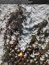
Satellite image from 29 April 2021


On 13 April 2021, 4 new craters formed in Geldingadalir within the lava flows. The lava output which had been somewhat reduced over the last days, increased again.[34]
Eruption fissures on Fagradalsfjall[]
Around noon on 5 April a new fissure, variously estimated to be between about 100 and 500 metres (300 and 2,000 ft) long, opened a distance of about 1 kilometre (0.5 mi) to the north/north-east of the still-active vents at the center of the March eruption. As a precaution the area was evacuated by the coast guard.[35][36][37]
Some time later, another eruption fissure opened parallel to the first on the slopes of Fagradalsfjall.[38]
The lava production of all open eruption fissures in the whole was estimated on 5 April 2021, being around 10 m3/s (350 cu ft/s) [39][40] and is flowing into the valley Meradalir ([ˈmɛːraˌtaːlɪr̥], "mare dale") via a steep gully.[41]

The new eruption fissures.
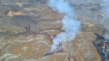
The new eruption fissures to the left, the older ones to the right, seen from a helicopter, view to the east.


About 36 hours later, around midnight on 6-7 April, another eruption fissure opened up. It is about 150 m (490 ft) long and about 400–450 m (1,300–1,500 ft) to the north-east of the first fissure, between the Geldingadalur fissures and the ones on the slope of the mountain.[42][43][44] Search and rescue crews observed a new depression, about 1 m (3 ft) deep there the previous day. The lava from this fissure flowed into Geldingadalur valley.[45]
Another fissure opened during the night of 10-11 April 2021 between the two open fissures on the slopes of Fagradalsfjall.[46]
By 2 May 2021, only one fissure, Vent 5, remained active. It developed into a volcano with the occasional explosive eruptions within its crater that sometimes reached heights of hundreds of meters.[47] The lava flowed into the Meradalir valley,[48] and later the Nátthagi [ˈnauhtˌhaijɪ] valley.[49] A small vent was reported to have opened close to the main crater on 1 July.[50] On 14 August, lava spurted from what appeared to be a hole on the crater wall, and this turned out to be an independent eruption.[51]
Lava and gas output: Development of the eruption[]
On 12 April, scientists from the University of Iceland measured the lava field's area to be 0.75 km2 (0.29 sq mi) and its volume to be 10.3 million m3 (360 million cu ft). The flow rate of the lava was 4.7 m3/s (170 cu ft/s), and sulfur dioxide, carbon dioxide and hydrogen fluoride were being emitted at 6,000, 3,000 and 8 tonnes per day (5,900, 3,000 and 7.9 long tons per day) respectively.[52]
The lava produced by the eruption shows a composition differing from historical Reykjanes lavas. This could be caused by a new batch of magma arriving from a large magma reservoir at a depth of about 17–20 km (11–12 mi) at the Moho under Reykjanes.[53][54][55]
- Examples of basaltic lava collected in late March


Results from measurements published by University of Iceland on 26 April 2021 showed that the composition of eruption products had changed, to more closely resemble the typical Holocene basalts of Reykjanes peninsula.[56] The eruption itself also changed in character at the same time, and was producing lava fountains up to 50 m (160 ft) in height on Sunday, 25 April 2021.[57] On 28 April 2021, the lava fountains from the main crater reached a height of 250 m (820 ft).[58]

The eruption pattern changed on 2 May from a continuous eruption and lava flow to a pulsating one, where periods of eruptions alternated with periods of inactivity, with each cycle lasting 10 minutes to half an hour.[59][60] The magma jets became stronger, producing lava fountains of 300 m (980 ft) in height, visible from Reykjavík,[61][62] with the highest one measured at 460 m (1,510 ft).[60] The lava jets have been explained as explosive release of ancient trapped water or magma coming in contact with groundwater.[63][64] The lava flow rate in the following weeks was also double that of the average for the first six weeks,[65] with an average lave flow rate of 12.4 m3/s (440 cu ft/s) from 18 May to 2 June.[66]
The increase in lava flow is unusual, as eruption outputs typically decrease with time. Scientists from the University of Iceland hypothesize that there is a large magma reservoir deep under the volcano, not the typical smaller magma chamber associated with these kinds of eruptions that empty over a short time.[67] From the composition of the magma sampled, they also believe that there is a discrete vent feeding the main lava flow from a depth of 17–20 kilometres (11–12 mi) from the Earth's mantle, and may be of a more primitive kind than those previously observed.[68] The eruption may create a new shield volcano if it continues for long enough.[69] The formation of such volcano has not been studied before in real time, offering insights into the working of the magmatic systems.[10]
Two defensive barriers were created starting 14 May as an experimentation to stop lava flowing into the Nátthagi valley where telecommunication cables are buried, and further on to the southern coastal road Suðurlandsvegur.[70] However, the lava soon flowed over the top of eastern barrier 22 May, and cascaded down to the Nátthagi.[71][72][73] Lava flowed over the western barrier on 5 June.[74] Lava flow blocked the main trail that provide access to the main viewing area, first on 4 June,[75] then again early in the morning of 13 June at another location.[76] A further wall five meters high and 200 meters long was then created on 15 June in an attempt to divert lava flow away from Nátthagakriki [ˈnauhtˌhaːɣaˌkʰrɪːcɪ] with important infrastructure to its west and north.[77] A barrier of 3 to 5 m high started to be constructed on 25 June at the mouth of Nátthagi to delay the flow of the lava over the southern coastal road and properties on Ísólfsskáli [ˈiːsˌoul(f)sˌskauːlɪ], although it was expected that the lava would eventually flow over the area into the sea.[78][79] A proposal to build a bridge over the road to allow the lava flow underneath was rejected.[80]
Around three months after the volcano first erupted, the lave flow was a steady 12 m3/s (420 cu ft/s), and the lava now covered an area of more than 3 km2 (1.2 sq mi) increasing by around 60,000 m2/d (650,000 sq ft/d).[81][82] Lava had accumulated 100 m (330 ft) deep around the volcano.[83] The lava flow became continuous, which can be either above or below ground, although the eruptions also became calmer with the occasional increase in activity.[84][85] There appeared to be no direct connection between the activity at the crater and lava flow.[86] The lava flow can be tracked by helicopter or satellite, for example via radar imaging that can penetrate through the clouds and volcanic smog that had become more frequent in the area by July.[87][88]
The eruptions stayed unusually constant until 23 June, and the activity then reduced significantly on 28 June, becoming inactive for many hours,[89][90] and resuming on 29 June.[91][92] It shifted to a pattern of many hours of inactivity, for example on 1 July and 4 July,[93][94] with the eruptions resuming later.[95] Lava flow from the crater ceased for 4 days from 5 July until 9 July,[96][97] when eruptions resumed, initially with a periodicity of around 10 to 15 minutes,[98] then lengthening to 3 to 4 an hour by 13 July.[99] Lava has also been observed emerging from the bottom of the volcano on 10 July with considerable amount of lava flowing into the Meradalir valley,[98][100][101] and a section of the volcano on the northeastern side also broke off on the 14 July.[102] Lava flow was estimated to be around 10 m3/s (350 cu ft/s) but averaged to 5 to 6 m3/s (180 to 210 cu ft/s) due to the periods of inactivity from late June to mid-July, half of the flow rate in May and June.[103] The periodic lull in activity continued in July and August,[104][105] often following a pattern of around 15 hours of inactivity alternating with around 20 hours of continuous eruption.[106] It has been speculated that there are blockages at the top hundred metres of the eruption channel.[105] By July, this eruption had become larger than most eruptions that have ever occurred on the Reykjanes peninsula.[107] Measurement taken on 27 July indicated that the lava flow had increased again, returned to and possibly exceeding the peak level last seen in June.[108] After a couple of months where the lava flowed mainly to Meradalir valley, the lava started to flow into the Nátthagi valley again on 21 August.[109][110]
Supposed burial site[]
The area where the volcano first erupted is thought to be the ancient burial site of an early Norse settler Ísólfur frá Ísólfsstöðum [ˈiːsˌoulvʏr frau ˈiːsˌoul(f)sˌstœːðʏm].[111] However, a quick archaeological survey of Geldingadalur after the eruption started found no evidence of human remains in the area.[112]
1943 accident[]

On 3 May 1943, LTG Frank Maxwell Andrews, a U.S. Army senior officer and founder of the United States Army Air Forces, was killed along with fourteen others when their B-24 aircraft Hot Stuff crashed into the side of the mountain.[113][114]
See also[]
- Volcanism in Iceland
- Geology of Reykjanes Peninsula
- Geography of Iceland
- Geology of Iceland
- List of volcanic eruptions on Iceland
Notes[]
- ^ "castration valleys", as the hollow was a convenient place for shepherds to castrate ram lambs. That hollow is now filled with new lava and cannot be seen.
References[]
- ^ Jump up to: a b c "Kortasjá". kortasja.lmi.is. Archived from the original on 20 June 2021. Retrieved 13 April 2021.
- ^ "G.M. Pedersen, Semi-automatic classification of glaciovolcanic landforms: An object-based mapping approach based on geomorphometry". Science direct. Journal of Volcanology and Geothermal Research 311 (2016), 29-40. Archived from the original on 13 April 2021. Retrieved 13 April 2021.
- ^ Jump up to: a b c d "Fagradalsfjall". Volcano Discovery.
- ^ "Archived copy". Archived from the original on 18 March 2021. Retrieved 20 March 2021.CS1 maint: archived copy as title (link)
- ^ Jump up to: a b ""Small" volcanic eruption in Iceland lights up night sky near Reykjavik". France 24. 20 March 2021. Archived from the original on 20 March 2021. Retrieved 20 March 2021.
- ^ Sæmundsson, Kristján; Sigurgeirsson, Magnús Á. (25 June 2018). "Hvað getið þið sagt mér um eldstöðvakerfið sem kennt er við Fagradalsfjall?". Vísindavefurinn.
- ^ Jump up to: a b "Upptök gossins eru í Geldingadal". www.mbl.is (in Icelandic). Archived from the original on 19 March 2021. Retrieved 21 March 2021.
- ^ "Iceland volcano: Eruption under way in Fagradalsfjall, near Reykjavik". The Guardian. 20 March 2021. Archived from the original on 19 March 2021. Retrieved 20 March 2021.
- ^ Einarsson, Guðni (14 July 2021). "Óljóst hvað stýrir gosóróa". mbl.is.
- ^ Jump up to: a b Ravilious, Kate (7 July 2021). "Terrawatch: witnessing a 'lava shield' volcano form". The Guardian.
- ^ Churm, Philip Andrew (10 May 2021). "An erupting volcano in Iceland is drawing tourists from around the world". EuroNews. Archived from the original on 22 May 2021. Retrieved 22 May 2021.
- ^ Sherwood, Harriet (18 April 2021). "Lava in a cold climate: Icelanders rush to get wed at volcano site". The Guardian. Archived from the original on 22 May 2021. Retrieved 22 May 2021.
- ^ Halldórsson, Skúli (5 May 2021). "Hraunið mun heita Fagradalshraun". mbl.is. Archived from the original on 5 May 2021. Retrieved 5 May 2021.
- ^ "Krýsuvík-Trölladyngja". Catalogue of Icelandic Volcanoes. Archived from the original on 19 March 2021. Retrieved 20 March 2021.
- ^ "Íslensk eldfjallavefsjá". icelandicvolcanos.is. Archived from the original on 24 March 2021. Retrieved 4 April 2021.
- ^ See eg.: Geirsson, H., Parks, M., Vogfjörd, K., Einarsson, P., Sigmundsson, F., Jónsdóttir, K., Drouin, V., Ófeigsson, B. G., Hreinsdóttir, S., and Ducrocq, C.: The 2020 volcano-tectonic unrest at Reykjanes Peninsula, Iceland: stress triggering and reactivation of several volcanic systems, EGU General Assembly 2021, online, 19–30 Apr 2021, EGU21-7534, https://doi.org/10.5194/egusphere-egu21-7534 Archived 20 June 2021 at the Wayback Machine, 2021. https://meetingorganizer.copernicus.org/EGU21/EGU21-7534.html Archived 21 April 2021 at the Wayback Machine Retrieved: 6 April 2021
- ^ See eg.: Geirsson, H., Parks, M., Vogfjörd, K., Einarsson, P., Sigmundsson, F., Jónsdóttir, K., Drouin, V., Ófeigsson, B. G., Hreinsdóttir, S., and Ducrocq, C.: The 2020 volcano-tectonic unrest at Reykjanes Peninsula, Iceland: stress triggering and reactivation of several volcanic systems, EGU General Assembly 2021, online, 19–30 Apr 2021, EGU21-7534, https://doi.org/10.5194/egusphere-egu21-7534 Archived 20 June 2021 at the Wayback Machine, 2021. https://meetingorganizer.copernicus.org/EGU21/EGU21-7534.html Archived 21 April 2021 at the Wayback Machine Retrieved: 6 April 2021
- ^ Peltier, Elian (4 March 2021). "In Iceland, 18,000 earthquakes over days signal possible eruption on the horizon". The New York Times. Archived from the original on 20 March 2021. Retrieved 20 March 2021.
- ^ "M 5.6 - 11 km SW of Álftanes, Iceland". USGS-ANSS. USGS. Archived from the original on 24 February 2021. Retrieved 20 March 2021.
- ^ "M 5.6 - 6 km SE of Vogar, Iceland". USGS-ANSS. USGS. Archived from the original on 1 March 2021. Retrieved 20 March 2021.
- ^ Hafstað, Vala (18 March 2021). "Earthquakes on Reykjanes peninsula explained". Iceland Monitor. Archived from the original on 20 March 2021. Retrieved 20 March 2021.
- ^ Frímann, Jón (24 February 2021). "Earthquake with magnitude 5,7 in Reykjanes volcano (update at 12:28 UTC)". Iceland Geology. Iceland Geology. Archived from the original on 28 February 2021. Retrieved 20 March 2021.
- ^ "Volcano erupts near Iceland's capital Reykjavik". BBC. BBC. 20 March 2021. Archived from the original on 5 June 2021. Retrieved 20 March 2021.
- ^ "Aukagígur sækir í sig veðrið". www.mbl.is (in Icelandic). Archived from the original on 23 March 2021. Retrieved 24 March 2021.
- ^ "Long dormant volcano comes to life in southwestern Iceland". US News. Associated Press. 19 March 2021. Archived from the original on 20 March 2021. Retrieved 20 March 2021.
- ^ Hafstað, Vala (20 March 2021). "'Best possible location' for eruption". Iceland Monitor. Archived from the original on 20 March 2021. Retrieved 20 March 2021.
- ^ Fontaine, Andie Sophia (19 March 2021). "Eruption at Fagradalsfjall". Grapevine. Reykjavik, IS. Archived from the original on 19 March 2021. Retrieved 20 March 2021.
- ^ Elliott, Alexander (19 March 2021). "Volcanic eruption: What we know so far". RÚV. Iceland. Archived from the original on 19 March 2021. Retrieved 20 March 2021.
- ^ We visited the volcano in Iceland & it blew our mind (video). RVK. Newscast #86 – via Youtube.
- ^ Jump up to: a b "Vísbendingar um dyngjugos sem getur varað í ár". www.mbl.is (in Icelandic). Archived from the original on 23 March 2021. Retrieved 24 March 2021.
- ^ "Gosið sést vel af höfuðborgarsvæðinu". www.mbl.is (in Icelandic). Archived from the original on 23 March 2021. Retrieved 24 March 2021.
- ^ ""Þetta er hálfgerð Þjóðhátíð hérna"". www.mbl.is (in Icelandic). Archived from the original on 24 March 2021. Retrieved 24 March 2021.
- ^ ""Ekkert í líkingu við það sem við höfum séð áður"". www.mbl.is (in Icelandic). Archived from the original on 4 June 2021. Retrieved 25 March 2021.
- ^ Björnsson, Ingvar Þór (13 April 2021). "Telja fjóra nýja gíga hafa opnast". RÚV (in Icelandic). Archived from the original on 13 April 2021. Retrieved 13 April 2021.
- ^ "BREAKING: New Fissure Opens North Of Geldingadalur, Area Evacuated". The Reykjavik Grapevine. 5 April 2021. Archived from the original on 5 April 2021. Retrieved 5 April 2021.
- ^ Pétursson, Vésteinn Örn; Hall, Sylvia (5 April 2021). "Ný sprunga að opnast á Reykjanesskaga" [A new crack opens on the Reykjanes peninsula]. Vísir (in Icelandic). Archived from the original on 5 April 2021. Retrieved 5 April 2021.
- ^ "Ný gossprunga skammt frá gosstöðvum í Geldingadölum" [New eruption fissure close to eruption sites in Geldingadalur]. Veðurstofa Íslands (in Icelandic). 5 April 2021. Archived from the original on 5 April 2021. Retrieved 5 April 2021.
- ^ https://www.ruv.is/frett/2021/04/05/tvaer-nyjar-sprungur-og-hraunid-rennur-i-meradali Archived 21 May 2021 at the Wayback Machine Tvær nýjar sprungur og hraunið rennur í Meradali. Ruv.is. 05.04.2021 - 14:05. Retrieved 6 April 2021
- ^ https://www.ruv.is/frett/2021/04/05/gosid-hefur-vaxid-10-rummetrar-af-kviku-a-sekundu Archived 5 April 2021 at the Wayback Machine Gosið hefur vaxið - 10 rúmmetrar af kviku á sekúndu. Ruv.is Retrieved: 6 April 2021
- ^ See also: http://jardvis.hi.is/eldgos_i_geldingadolum Archived 7 April 2021 at the Wayback Machine Eldgos í geldingadölum. Háskóli Íslands. Jarðvínsindastofnun. Retrieved: 6 April 2021
- ^ "Reykjanes surprise". VolcanoCafe. 5 April 2021. Archived from the original on 5 April 2021. Retrieved 7 April 2021.
- ^ https://en.vedur.is/#tab=quakes Archived 6 April 2021 at the Wayback Machine Specialist remark. Earthquake page of Icelandic Met Office. Retrieved 7 April 2021.
- ^ See also https://www.ruv.is/frett/2021/04/07/ny-sprunga-buin-ad-opnast Archived 7 April 2021 at the Wayback Machine RÚV: Ný sprunga búin að opnast. Retrieved 7 April 2021
- ^ "From Iceland — A New Fissure Has Opened At Geldingadalur". The Reykjavik Grapevine. 7 April 2021. Archived from the original on 7 April 2021. Retrieved 7 April 2021.
- ^ Ćirić, Jelena (7 April 2021). "Reykjanes Eruption: Third Fissure Opens". Iceland Review. Archived from the original on 20 June 2021. Retrieved 7 April 2021.
- ^ See eg. https://www.ruv.is/frett/2021/04/10/ny-sprunga-opnadist-i-geldingadolum-i-nott Archived 13 April 2021 at the Wayback Machine RÚV. Ný sprunga opnaðist í Geldingadölum í nótt. Retrieved: 13 April 2021
- ^ Julavits, Heidi (16 August 2021). "Chasing the Lava Flow in Iceland". The New Yorker.
- ^ "Skjálfti upp á 3,2 við Kleifarvatn -- gosvirkni svipuð". RÚV (in Icelandic). 3 May 2021. Archived from the original on 3 May 2021. Retrieved 3 May 2021.
- ^ "Fagradalsfjall volcano update: Lava overflows dam, enters valley towards southern Ring Road now in dager being cut". 23 May 2021. Archived from the original on 27 May 2021. Retrieved 18 June 2021.
- ^ "Gosið í fullu fjöri". mbl.is. 1 July 2021.
- ^ Tryggvason, Tryggvi Páll (16 August 2021). "Nýjasta gosopið í góðum gír". Vísir.
- ^ http://jardvis.hi.is/eldgos_i_fagradalsfjalli Archived 12 April 2021 at the Wayback Machine Jarðvísíndastofnun Háskóla Íslands Retrieved: 13 April 2021
- ^ "New trace element and isotope analyses of the Geldingadalir lava". Institute of Earth Sciences. 1 April 2021. Archived from the original on 13 April 2021. Retrieved 13 April 2021.
- ^ "Characterisation of rock samples collected in the first week of the eruption-trace elements and Pb-isotopes" (PDF). Institute of Earth Sciences. Archived (PDF) from the original on 14 April 2021. Retrieved 14 April 2021.
- ^ "Characterisation of rock samples collected on the 1st and 2nd days of the eruption in Geldingdalur". Institute of Earth Sciences. Archived from the original on 13 April 2021. Retrieved 13 April 2021.
- ^ Eldgos í Fagradalsfjalli. Archived 12 April 2021 at the Wayback Machine Jarðvísindastofnun. Háskóli Íslands. Retrieved 28 April 2021.
- ^ Eldgosið síðasta sólarhringinn – aukin sprengivirkni. Archived 28 April 2021 at the Wayback Machine RúV. 27 April 2021. Retrieved 28 April 2021
- ^ "Eldskýstrßokar við eldstöðvarnar í gær". RÚV. 29 April 2021. Archived from the original on 29 April 2021. Retrieved 29 April 2021.
- ^ "Icelandic volcano becomes more volatile and powerful". Euronews. 3 May 2021. Archived from the original on 20 June 2021. Retrieved 6 May 2021.
- ^ Jump up to: a b Bressen, David (10 May 2021). "Volcanic Eruption Illuminates Reykjavik's Night Sky With Lava Fountains Up to 460 Meters High". Forbes. Archived from the original on 22 May 2021. Retrieved 22 May 2021.
- ^ "Myndarlegir strókar standa upp af gosinu". RÚV. 5 May 2021. Archived from the original on 5 May 2021. Retrieved 6 May 2021.
- ^ "Gígurinn þeytir kviku 300 metra upp í loft". RÚV. 2 May 2021. Archived from the original on 5 May 2021. Retrieved 6 May 2021.
- ^ Steinþórsson, Sigurður (24 June 2021). "Hvaðan kemur vatnið sem veldur sprengingum í gígnum í Geldingadölum?". Vísindavefurinn.
- ^ Hallsdóttir, Esther (24 June 2021). "Eldgamalt vatn veldur sprengingunum". mbl.is.
- ^ "Eldgosið tveggja mánaða og tvöfalt stærra en í upphafi". RUV.is. 19 May 2021. Archived from the original on 22 May 2021. Retrieved 22 May 2021.
- ^ Guðrún Hálfdánardóttir (4 June 2021). "Breytingar á óróavirkni gossins". mbl.is. Archived from the original on 5 June 2021. Retrieved 5 June 2021.
- ^ https://www.ruv.is/frett/2021/05/11/different-eruption-than-we-are-used-to Archived 12 May 2021 at the Wayback Machine "Different eruption than we are used to" RúV (English language pages). 11 May 2021. Retrieved 13 May 2021
- ^ Hafstað, Vala (23 March 2021). "Long-Lasting Shield Volcano Eruption? Magma from Mantle". Iceland Monitor.
- ^ https://www.ruv.is/frett/2021/05/11/stor-kutur-fullur-af-kviku-undir-gosinu Archived 13 May 2021 at the Wayback Machine Stór kútur fullur af kviku undir gosinu. RÚV. 11 May 2021. Retrieved 12 May 2021. See also the [data from University of Iceland (data from 10 May 2021, retrieved 13 May 2021]) http://jardvis.hi.is/eldgos_i_fagradalsfjalli}}
- ^ Ásgrímsson, Þorsteinn (15 May 2021). "Leggja lokahönd á fyrri varnargarðinn". mbl.is. Archived from the original on 15 May 2021. Retrieved 15 May 2021.
- ^ Lilja Hrund Ava Lúðvíksdóttir (22 May 2021). "Komi ekki á óvart að hraun renni yfir varnargarðinn". mbl.is. Archived from the original on 22 May 2021. Retrieved 22 May 2021.
- ^ Rúnarsson, Bjarni (22 May 2021). "Logandi hraunflaumurinn rennur niður í Nátthaga". RUV.is. Archived from the original on 22 May 2021. Retrieved 22 May 2021.
- ^ RÚV (25 May 2021). "Lava tops barriers as small earthquake draws attention". Archived from the original on 25 May 2021. Retrieved 18 June 2021.
- ^ Ólafsdóttir, Kristín (5 June 2021). "Hraunspýja rauf vestari varnargarðinn". Vísir. Archived from the original on 5 June 2021. Retrieved 5 June 2021.
- ^ Sigurðardóttir, Elísabet Inga (4 June 2021). "Hraun komið yfir gönguleiðina upp á útsýnishólinn". Vísir. Archived from the original on 5 June 2021. Retrieved 16 June 2021.
- ^ "Hætta á að hraun flæði yfir á fleiri stöðum". RÚV. 13 June 2021. Archived from the original on 14 June 2021. Retrieved 16 June 2021.
- ^ "Reyna að stýra leið hraunflæðis". mbl.is. 16 June 2021. Archived from the original on 14 June 2021. Retrieved 16 June 2021.
- ^ Sæberg, Árni (25 June 2021). "Varnargarður rís í Nátthaga". Vísir.
- ^ "Hraunið nái að Suðurstrandarvegi á næstu vikum". mbl.is. 25 June 2021.
- ^ "Almannavarnir munu ekki leggja hraunbrú". mbl.is. 1 July 2021.
- ^ Elliott, Alexander (15 June 2021). "Nine football pitches of lava per day". RÚV. Archived from the original on 15 June 2021. Retrieved 19 June 2021.
- ^ "Mun stærra en í upphafi". mbl.is. 18 June 2021. Archived from the original on 20 June 2021. Retrieved 19 June 2021.
- ^ "Hraunið orðið hundrað metrar að þykkt". RÚV. 9 June 2021. Archived from the original on 9 June 2021. Retrieved 16 June 2021.
- ^ "Allar mælingar benda til að hraunflæðið sé svipað". RÚV. 10 June 2021. Archived from the original on 10 June 2021. Retrieved 16 June 2021.
- ^ "Strókavirkni jókst í eldgosinu í nótt". RÚV. 11 June 2021. Archived from the original on 11 June 2021. Retrieved 16 June 2021.
- ^ Einarsson, Guðni (6 July 2021). "Gígurinn fylgir ekki flæðinu". mbl.is.
- ^ Amos, Jonathan (7 July 2021). "Iceland's spectacular volcano tracked from space". BBC.
- ^ Grettisson, Valur (8 July 2021). "RVK Newscast #115: The Odd Rhythm Of The Volcano & A Helicopter Dispute". Reykjavic Grapevine.
- ^ Unnarsson, Kristján Már (6 July 2021). "Gosið í dvala í sólarhring í lengsta hléi frá upphafi". Vísir.
- ^ "Did Part of Crater Rim Collapse?". Iceland Monitor. 30 June 2021.
- ^ Kiner, Brittnee (1 July 2021). "Volcano Revives Itself After Fears Of Eruption Ending". Reykjavic Grapevine.
- ^ "Ljóst að gosinu er ekki lokið". mbl.is. 29 June 2021.
- ^ "Lítil sem engin virkni í eldgosinu". mbl.is. 1 July 2021.
- ^ Pétursson, Vésteinn Örn (4 July 2021). "„Gerum allt eins ráð fyrir því að óróinn taki sig upp að nýju"". Vísir.
- ^ Unnarsson, Kristján Már (4 July 2021). "Hraunslettur í gígnum á ný eftir sextán stunda goshlé". Vísir.
- ^ "Ennþá virkni í gosinu". mbl.is. 9 July 2021.
- ^ Unnarsson, Kristján Már (10 July 2021). "Hraunslettur í gígnum á ný og óróinn rýkur upp". Vísir.
- ^ Jump up to: a b Ólafsdóttir, Kristín (11 July 2021). "Hraunið streymir niður í Meradali gegnum gat í gígnum". Vísir.
- ^ Þórhallsson, Markús Þ. (13 July 2021). "Hraunstraumur rennur fagurlega niður í Meradali". RÚV.
- ^ "Öflugur hraunfoss rennur úr gígnum niður í Meradali". RÚV. 10 July 2021.
- ^ Kolbeins, Steinar Ingi (16 July 2021). "Hraun rennur taktfast niður í Meradali". mbl.is.
- ^ "Mikið gengið á við gosstöðvarnar". mbl.is. 15 July 2021.
- ^ "Dregur úr kvikumagninu segir Magnús Tumi - enginn órói". RÚV. 16 July 2021.
- ^ "Gosóróinn farinn upp og gígurinn að fyllast". mbl.is. 16 July 2021.
- ^ Jump up to: a b Ríkharðsdóttir, Karítas (17 July 2021). "Gosóróinn dottinn niður á ný". mbl.is.
- ^ Tryggvason, Tryggvi Páll (27 August 2021). "Gosið hafi mannast". Vísir.
- ^ Unnarsson, Kristján Már (8 July 2021). "Eldgosið í Fagradalsfjalli orðið stærra en meðalgos á svæðinu". Vísir.
- ^ Bjarnar, Jakob (29 July 2021). "Gosið hrekkjótt og lætur vísindamenn hafa fyrir sér". Vísir.
- ^ Kolbeinsson Proppé, Óttar (21 August 2021). "Hraun rennur aftur í Nátthaga en langt í Suðurstrandarveg". Vísir. soft hyphen character in
|title=at position 26 (help) - ^ "Augnakonfekt í Nátthaga". RÚV. 27 August 2021.
- ^ "Reykjanes eruption in Iceland continues at steady pace, might go on for weeks". Volcano Discovery. Archived from the original on 24 May 2021. Retrieved 24 May 2021.
- ^ Másson, Snorri (21 March 2021). "Mannvistarleifar glötuðust ekki". mbl.is. Archived from the original on 24 March 2021. Retrieved 24 May 2021.
- ^ "Mt Fagradalsfjall". Visit Reykjanes. Archived from the original on 1 March 2021. Retrieved 20 March 2021.
- ^ Yenne, Bill (2015). Hit the Target: Eight men who led the Eighth Air Force to victory over the Luftwaffe. Penguin Group. p. 184. ISBN 9780698155015. Archived from the original on 9 April 2021. Retrieved 20 March 2021 – via Google Books.
External links[]
| Wikimedia Commons has media related to Fagradalsfjall (Reykjanes). |
- "Krýsuvík-Trölladyngja". Global Volcanism Program. Smithsonian Institution. Retrieved 2 August 2021.
- Data from University of Iceland re. the eruption at Fagradalsfjall (continuously updated)
- Icelandic Met Office: Gas dispersion forecast
- A volcanic eruption has begun — Icelandic Met Office
- Video by Icelandic Meteorological Office taken a few hours after the eruption started
- Live video of the March 2021 eruption
- RÚV. Video of the eruption on 12 April 2021
- Interactive 3D model of the lava flows as of 18 April 2021.
- 21st-century volcanic events
- Active volcanoes
- Fissure vents
- Krýsuvík Volcanic System
- Lava lakes
- Reykjanes Volcanic Belt
- Subglacial volcanoes of Iceland
- Tuyas of Iceland
- Tuyas
- Volcanic eruptions in 2021