Fagurhólsmýri
Fagurhólsmýri | |
|---|---|
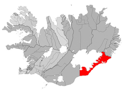 Location of the Municipality of Sveitarfélagið Hornafjörður | |
 Fagurhólsmýri Location of Fagurhólsmýri in Iceland | |
| Coordinates: 63°52′N 16°38′W / 63.867°N 16.633°W | |
| Country | |
| Constituency | South Constituency |
| Region | Eastern Region |
| Municipality | Sveitarfélagið Hornafjörður |
| Time zone | UTC+0 (GMT) |

Fagurhólsmýri (Icelandic pronunciation: [ˈfaːɣʏrˌhoulsˌmiːrɪ]; 63°53′00″N 16°39′00″W / 63.883333°N 16.65°W) is a small village in southern Iceland, located roughly ten kilometres south of the Oraefajokull volcano. The village has its own airport. Local attractions include Ingólshöfdi which is a trail.[1][2]
References[]
- ^ "Fagurhólsmýri", . Retrieved on 13 February 2018.
- ^ "Ingólshöfdi", . Retrieved on 13 February 2018.
Coordinates: 64°07′59″N 20°19′59″W / 64.133°N 20.333°W
This Iceland location article is a stub. You can help Wikipedia by . |
Categories:
- Populated places in Eastern Region (Iceland)
- Iceland geography stubs