Fanari, Preveza
Fanari
Φανάρι | |
|---|---|
 Fanari Location within the regional unit 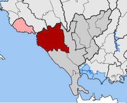 | |
| Coordinates: 39°14′N 20°36′E / 39.233°N 20.600°ECoordinates: 39°14′N 20°36′E / 39.233°N 20.600°E | |
| Country | Greece |
| Administrative region | Epirus |
| Regional unit | Preveza |
| Municipality | Parga |
| • Municipal unit | 205.9 km2 (79.5 sq mi) |
| Population (2011)[1] | |
| • Municipal unit | 7,962 |
| • Municipal unit density | 39/km2 (100/sq mi) |
| Time zone | UTC+2 (EET) |
| • Summer (DST) | UTC+3 (EEST) |
| Vehicle registration | ΡΖ |

Fanari (Greek: Φανάρι) is a former municipality in the Preveza regional unit, Epirus, Greece. Since the 2011 local government reform it is part of the municipality Parga, of which it is a municipal unit.[2] The municipal unit has an area of 205.893 km2.[3] Population 7,962 (2011). The seat of the municipality was in .
Subdivisions[]
The municipal unit Fanari is subdivided into the following communities:
References[]
- ^ a b "Απογραφή Πληθυσμού - Κατοικιών 2011. ΜΟΝΙΜΟΣ Πληθυσμός" (in Greek). Hellenic Statistical Authority.
- ^ "ΦΕΚ B 1292/2010, Kallikratis reform municipalities" (in Greek). Government Gazette.
- ^ "Population & housing census 2001 (incl. area and average elevation)" (PDF) (in Greek). National Statistical Service of Greece. Archived from the original (PDF) on 2015-09-21.
This Epirus location article is a stub. You can help Wikipedia by . |
Categories:
- Populated places in Preveza (regional unit)
- Epirus geography stubs