Fenriskjeften Mountain
Coordinates: 71°53′S 8°18′E / 71.883°S 8.300°E

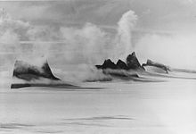
Fenriskjeften covered by fog
Fenriskjeften Mountain is a large bare rock mountain which in plan resembles a hairpin, forming the southern portion of the Drygalski Mountains in Queen Maud Land, Antarctica. It was plotted from air photos by the Third German Antarctic Expedition (1938–39), mapped from surveys and air photos by the Sixth Norwegian Antarctic Expedition (1956–60), and because of its shape named Fenriskjeften (Fenrir's jaw), after the wolf in Norse mythology.[1]
See also[]
References[]
- ^ "Fenriskjeften Mountain". Geographic Names Information System. United States Geological Survey. Retrieved 2012-03-20.
![]() This article incorporates public domain material from the United States Geological Survey document: "Fenriskjeften Mountain". (content from the Geographic Names Information System)
This article incorporates public domain material from the United States Geological Survey document: "Fenriskjeften Mountain". (content from the Geographic Names Information System)
Categories:
- Mountains of Queen Maud Land
- Orvin Mountains
- Princess Astrid Coast geography stubs