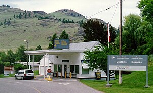
Ferry–Midway Border Crossing
| Ferry–Midway Border Crossing | |
|---|---|
 Canada Border Inspection Station at Midway, BC | |
| Location | |
| Country | United States; Canada |
| Location |
|
| Coordinates | 49°00′00″N 118°45′40″W / 49.000077°N 118.761091°WCoordinates: 49°00′00″N 118°45′40″W / 49.000077°N 118.761091°W |
| Details | |
| Opened | 1896 |
| Hours | Open 9:00AM - 5:00PM |
| Website http://www.cbp.gov/contact/ports/oroville-wa | |
U.S. Inspection Station – Ferry, Washington | |
| MPS | U.S. Border Inspection Stations MPS |
| NRHP reference No. | 14000611 |
| Added to NRHP | September 10, 2014 |
The Ferry–Midway Border Crossing connects the town of Curlew, Washington with Midway, British Columbia on the Canada–US border. Canada has had a customs office at this crossing since 1896, which coincided with the gold rush boom in the area. As the mining boom subsided, the population of the town of Ferry, Washington waned, and has effectively disappeared.[1] The current US border station was built in 1936, and the Canada border station was built in 1951. The US border station was listed on the US National Register of Historic Places 2014.

US Border Inspection Station in Ferry, WA as seen in 1999
See also[]
- List of Canada–United States border crossings
- National Register of Historic Places listings in Ferry County, Washington
References[]
- ^ Madilane Perry (2008). "A Brief History of Ferry County" (PDF). Ferry County Historical Society. Retrieved 2015-01-03.
Categories:
- Canada–United States border crossings
- Government buildings on the National Register of Historic Places in Washington (state)
- National Register of Historic Places in Ferry County, Washington
- West Kootenay
- 1896 establishments in British Columbia
- 1896 establishments in Washington (state)
