Figges Marsh


Figges Marsh is a 25-acre [1] public park in the London Borough of Merton. It is in Mitcham, close to Tooting railway station.[2]
Originally, the park was next to a toll road into London,[3] which was turnpiked in 1745;[4] now known as London Road.
The Name[]
The park was named after William Figge who occupied the land from 1357.[5] In maps of 1750, it is referenced as Piggs Marsh; in 1800, as Pigs Marsh Common [see External Source, The Underground Map, for map extracts].
Signage, erected in 2012, at the southern end of Figges Marsh, suggested the park may have been renamed 'Queen Elizabeth II Field' (as below, Photo Gallery); in the pecking order of park nomenclature, in terms of status, 'marsh' may be towards the bottom end. However, this was an endorsement exercise to celebrate the Queen's Diamond Jubilee & the 2012 London Olympics. The parks that participated in the scheme received a commemorative plaque, an oak sapling &, potentially, access to an improvement grant.[6][7]
Surrounding Area[]
At the eastern boundary of Figges Marsh, during the medieval period, was the Biggin Farm estate.
Industry developed at the southern end of the park from 1800. The Pascall's confectionery factory was located here in 1888, built on land purchased from James Bridger's Manor Farm,[8] taking advantage of the locally grown peppermint oil.[9][10][11][12]
However, the area to the east and west remained agricultural and open; Swain's & Tamworth farm, at the western boundary of Figges Marsh, are made reference to in the 1900 map [The Underground Map, as below]. That is, until the development of housing in the Victorian & Edwardian period.
References[]
- ^ "Figges Marsh". www.merton.gov.uk. Retrieved 2021-07-31.
- ^ "Figges Marsh". Merton Town Council. 2008-12-23. Retrieved 2009-07-28.
- ^ Wade (2015-05-24). "Figges Marsh Toll Gate". Mitcham History Notes. Retrieved 2021-07-31.
- ^ "Restoration and Early Georgian Mitcham". MERTON HISTORICAL SOCIETY. 2017-07-31. Retrieved 2021-07-31.
- ^ "Figge's Marsh | Hidden London". Retrieved 2021-07-31.
- ^ "Queen Elizabeth II Field - Wikishire". wikishire.co.uk. Retrieved 2021-07-31.
- ^ "Figges Marsh | Fields in Trust". www.fieldsintrust.org. Retrieved 2021-10-17.
- ^ Wade (2016-03-12). "James Pascall, Ltd". Mitcham History Notes. Retrieved 2021-07-31.
- ^ Wade (2017-02-17). "Peppermint in 1875". Mitcham History Notes. Retrieved 2021-07-31.
- ^ "Mentha". iwr.msu.edu. Retrieved 2021-07-31.
- ^ "Farming mint". The Field. 2008-05-19. Retrieved 2021-07-31.
- ^ "Sir Michael Colman, the man who is reviving the English mint crop". the Guardian. 2007-07-22. Retrieved 2021-07-31.
External Sources[]
- The Underground Map.com – historical map of Figges Marsh from 1900
- Wikipedia, Toll Roads in Great Britain - summary of toll roads/turnpikes, in Great Britain
- Figges Marsh photograph from 1950s
Photo gallery[]
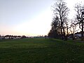
Figges Marsh, looking south, alongside London Road (at sunset, Dec 2020)

Name plate erected at southern end of Figges Marsh in 2012

Name plate erected at southern end of Figges Marsh in 2012
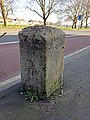
London Road milestone opposite Figges Marsh, looking south east
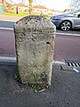
London Road milestone opposite Figges Marsh, looking east

London Road milestone opposite Figges Marsh, looking north

London Road milestone opposite Figges Marsh, looking south west


Coordinates: 51°24′50″N 0°09′36″W / 51.414°N 0.160°W

- Parks and open spaces in the London Borough of Merton