Fingringhoe
| Fingringhoe | |
|---|---|
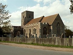 St. Andrew's church, Fingringhoe | |
 Fingringhoe Location within Essex | |
| Population | 770 (2011)[1] |
| OS grid reference | TM029203 |
| Civil parish |
|
| District |
|
| Shire county | |
| Region | |
| Country | England |
| Sovereign state | United Kingdom |
| Post town | Colchester |
| Postcode district | CO5 |
| Dialling code | 01206 |
| Police | Essex |
| Fire | Essex |
| Ambulance | East of England |
| UK Parliament | |
| Website | fingringhoe.info |

Fingringhoe is a village and civil parish in Essex, England located five miles south-east of Colchester. The centre of the village is classified as a conservation area featuring a traditional village pond and red telephone box. The Roman River flows nearby before entering the River Colne.[3] It has frequently been noted on lists of unusual place names.[4]
Geography[]
Fingringhoe Wick[]
Fingringhoe is locally known for its salt marshes, which provide habitats for many birds and salt-water animals. These form part of the Fingringhoe Wick Nature Reserve managed by Essex Wildlife Trust.[3]
History[]
Roman port[]
During the 1st Century AD Fingringhoe was home to a river port which serviced the nearby provincial capital of Roman Britain at Camulodunum (modern Colchester).[5][6]
Middle Ages[]
A manor located at Fingringhoe was donated by Henry I of England to the Norman abbey of Saint-Ouen at Rouen.[7]
Trivia[]
Fingringhoe is mentioned in Lemon Jelly's "Ramblin' Man" and is in the top 20 list of "rude names" from the book Rude Britain.
Fingringhoe is one of many British towns and villages referenced in Karl Marx's Das Kapital as part of "Illustrations of the General Law of Capitalist Accumulation".[8]
In 2009, an unexploded World War Two bomb was disarmed in the village.
Monuments[]
St. Andrew's Church[]
A prominent feature in the centre of the village, the north wall of St. Andrew's Church dates back to the 12th century.[9]
References[]
- ^ "Civil Parish population 2011". Retrieved 29 September 2015.
- ^ "FPC".
- ^ Jump up to: a b M.P.B. Fautley; J.H. Garon (1 July 2004). Essex Coastline: Then and Now. Matthew Fautley. p. 46. ISBN 978-0-9548010-0-7. Retrieved 17 July 2012.
- ^ Parker, Quentin (2010). Welcome to Horneytown, North Carolina, Population: 15: An insider's guide to 201 of the world's weirdest and wildest places. Adams Media. pp. ix. ISBN 9781440507397.
- ^ "Iron-Age and Roman Colchester", A History of the County of Essex: Volume 9: The Borough of Colchester (1994): 2-18, Janet Cooper, C R Elrington (Editors), A P Baggs, Beryl Board, Philip Crummy, Claude Dove, Shirley Durgan, N R Goose, R B Pugh, Pamela Studd, C C Thornton.. British History Online. Web. 01 June 2014
- ^ Crummy, Philip (1997) City of Victory; the story of Colchester - Britain's first Roman town. Published by Colchester Archaeological Trust (ISBN 1 897719 04 3)
- ^ Véronique Gazeau, Normannia monastica: Prosopographie des abbés bénédictins (Xe siècle-XIIe siècle), Publications du CRAHM, Caen, 2007.
- ^ Karl Marx, Samuel Moore (Translator), Edward Aveling (Translator) (15 December 2009). Das Kapital. MobileReference. p. 853. ISBN 978-1-60501-933-8. Retrieved 17 July 2012.CS1 maint: multiple names: authors list (link)
- ^ James Bettley; Nikolaus Pevsner (2 August 2007). Essex. Yale University Press. p. 362. ISBN 978-0-300-11614-4. Retrieved 17 July 2012.
External links[]
This Essex location article is a stub. You can help Wikipedia by . |
- Borough of Colchester
- Villages in Essex
- Essex geography stubs