Finse
Finse | |
|---|---|
Village | |
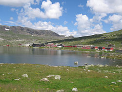 View of the village | |
 Finse Location of the village | |
| Coordinates: 60°36′06″N 07°30′14″E / 60.60167°N 7.50389°ECoordinates: 60°36′06″N 07°30′14″E / 60.60167°N 7.50389°E | |
| Country | Norway |
| Region | Western Norway |
| County | Vestland |
| District | Hardanger |
| Municipality | Ulvik |
| Elevation | 1,222 m (4,009 ft) |
| Time zone | UTC+01:00 (CET) |
| • Summer (DST) | UTC+02:00 (CEST) |
| Post Code | 5719 Finse |


Finse is a mountain village area on the shore of the lake Finsevatnet in Ulvik municipality in Vestland county, Norway. The village is centered on Finse Station, a railway station on the Bergen Line. The village sits at an elevation of 1,222 metres (4,009 ft) above sea level, making it the highest station on the entire Norwegian railway system. The village lies in the eastern part of Ulvik municipality, and it is not easily accessible from the rest of the municipality. There is no road access, only a railway stop. The long Finse Tunnel lies just west of the village area, replacing a difficult section of rail that frequently was blocked by snow and difficult to clear. According to the BBC, the village was used for expedition training by Amundsen, Scott and Shackleton.[2]
Transportation[]


Since there are no (public) roads to Finse, the railway provides the sole means of transportation to and from Finse. During summer, however, it is possible to walk or cycle to Finse on the Rallarvegen road (owned by the railroad). Across the railway line from the station is housed the railway navvy museum, which has exhibits on the construction of the railway line and two decommissioned snow-clearing engines which you are free to explore. The area also has a hotel (Finse 1222), a hostel (Finsehytta, DNT), and many private cabins.[3]
Recreation[]
During the winter, Finse is popular for cross-country skiing, sail skiing (due to its location on the edge of the frozen lake Finsevatnet), expedition training, and Red Cross training. The ill-fated Scott expedition to the South Pole trained here, and outside the hotel there is a monument to those that died. There is one small drag-lift which allows you to downhill ski on one slope back into town.[4]
During the summer, the recreational focus switches to mountain cycling, walking, and glacier walking on the adjacent "blue ice" Hardangerjøkulen glacier. The Rallarvegen is a popular bicycle route, from Haugastøl to Flåm.
Research[]
Finse is home to the Alpine Research Center operated by the University of Oslo and University of Bergen. The Centre began its work in 1972, initially under the title of the High Mountain Ecological Research Station. The Centre hosts numerous workshops, conferences, and research projects from both Norwegian and international institutions. It is part of EU-funded International Network for Terrestrial Research and Monitoring in the Arctic (INTERACT).[5]
In culture[]
Finse is the setting for the climax to the 1948 Hammond Innes novel The Blue Ice.
In March 1979, Finse was the location chosen to portray the ice planet Hoth in The Empire Strikes Back, the sequel to the 1977 Star Wars film. Other areas in Finse were used to create the Hoth map in the 2015 video game Star Wars Battlefront.
The Finse Tunnel, the village, and the "Finse 1222" Hotel are the setting of Anne Holt's 2007 novel 1222.
References[]
- ^ "Finse, Ulvik" (in Norwegian). yr.no. Retrieved 25 May 2014.
- ^ "The search for a new Earth". BBC. Retrieved 14 September 2017.
- ^ Store norske leksikon. "Finse" (in Norwegian). Retrieved 25 May 2014.
- ^ Kolbjørnsen, Mia. "A feeling for snow". University of Bergen. Archived from the original on 1 October 2013.
- ^ Tidemann, Grethe (2010). "UiOs forskningsstasjon på Finse: Undervisning på høyt nivå" (in Norwegian).
External links[]
| Wikimedia Commons has media related to Finse. |
| Wikivoyage has a travel guide for Finse. |
- Finse (in Norwegian)
- Finse1222 Hotel
- Kitebrothers.no
- 360 Panoramas from Finse
- HD YouTube video of the Finse portion of the Bergen Line, an HD video of the rail journey from Bergen to Oslo, Norway produced by NRK (Norwegian National Broadcasting).
- Finse Alpine Research Centre
- University of Oslo
- EU Interact
| hide Authority control | |
|---|---|
| General |
|
| National libraries | |
- Ulvik
- Villages in Vestland