Fire Control Tower No. 23
Fire Control Tower No. 23 | |
 | |
 | |
| Location | Sunset Boulevard, Lower Township, New Jersey |
|---|---|
| Coordinates | 38°56′36″N 74°58′3″W / 38.94333°N 74.96750°WCoordinates: 38°56′36″N 74°58′3″W / 38.94333°N 74.96750°W |
| Area | less than one acre |
| Built | 1942 |
| Architectural style | Fire Control Tower |
| NRHP reference No. | 03000655[1] |
| NJRHP No. | 4169[2] |
| Significant dates | |
| Added to NRHP | November 17, 2003 |
| Designated NJRHP | May 29, 2003 |
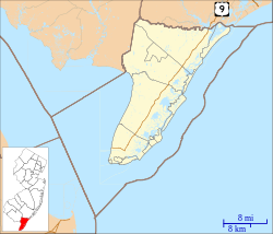
Fire Control Tower No. 23 is a NRHP-listed tower located in Lower Township, Cape May County, New Jersey, United States. The tower was built in 1942 as part of Fort Miles, the system of harbor defenses of the Delaware Bay. It was one of 15 towers from North Wildwood, New Jersey to Bethany Beach, Delaware used to aim coastal batteries at German ships and submarines. It is located near Sunset Beach in Cape May Point State Park.
The tower was added to the New Jersey Register of Historic Places on May 29, 2003, and to the National Register of Historic Places on November 17, 2003. About this time the tower was renovated under the direction of architect Robert Russell. Spiral staircases, lighting and safety features were installed, allowing the public to climb to the top of the tower and a wooden walkway was built to Sunset Avenue.[3]
See also[]
- National Register of Historic Places listings in Cape May County, New Jersey
- Battery 223
- Fire Control Tower
References[]
- ^ "National Register Information System". National Register of Historic Places. National Park Service. March 13, 2009.
- ^ "New Jersey and National Registers of Historic Places - Cape May County" (PDF). New Jersey Department of Environmental Protection - Historic Preservation Office. January 10, 2010. p. 12. Retrieved March 27, 2010.[dead link]
- ^ "World War II Lookout Tower". Mid-Atlantic Center for the Arts & Humanities. Archived from the original on 2011-07-28. Retrieved September 21, 2011.
- Government buildings completed in 1942
- Lower Township, New Jersey
- Buildings and structures in Cape May County, New Jersey
- Military facilities on the National Register of Historic Places in New Jersey
- National Register of Historic Places in Cape May County, New Jersey
- New Jersey Register of Historic Places
- 1942 establishments in New Jersey
- New Jersey Registered Historic Place stubs


