Firth River
| Firth River | |
|---|---|
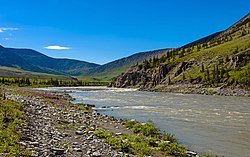 Firth River above Wolf Creek confluence, Ivvavik National Park | |
| Location | |
| Countries | United States, Canada |
| States | Alaska, Yukon |
| Physical characteristics | |
| Source | |
| • coordinates | 68°28′40″N 141°53′31″W / 68.4777778°N 141.8919444°W |
| Mouth | Beaufort Sea, Arctic Ocean |
• location | East of Gordon, Alaska |
• coordinates | 69°33′00″N 139°30′00″W / 69.5500000°N 139.5000000°WCoordinates: 69°33′00″N 139°30′00″W / 69.5500000°N 139.5000000°W[1] |
• elevation | 0 ft (0 m) |

Firth River is a major river in Yukon, Canada. It begins at the east side of Davidson Mountains and flows into the Beaufort Sea of the Arctic Ocean, east of Gordon, Alaska.
References[]
- ^ "Firth River". Geographic Names Information System. United States Geological Survey. Retrieved 2020-04-21.
Categories:
- Rivers of North Slope Borough, Alaska
- Rivers of Alaska
- Rivers of Yukon