Fischa
| Fischa | |
|---|---|
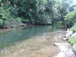 The Fischa at Mitterndorf | |
| Location | |
| Country | Austria |
| State | Lower Austria |
| Physical characteristics | |
| Mouth | |
• location | Danube near Fischamend |
• coordinates | 48°07′11″N 16°40′38″E / 48.1196°N 16.6771°ECoordinates: 48°07′11″N 16°40′38″E / 48.1196°N 16.6771°E |
| Length | 49.5 km (30.8 mi) [1] |
| Basin size | 210 km2 (81 sq mi) [1] |
| Basin features | |
| Progression | Danube→ Black Sea |

The Fischa (German pronunciation: [ˈfɪʃa] (![]() listen)) is a river of Lower Austria. It is a right tributary of the Danube near the town Fischamend.
listen)) is a river of Lower Austria. It is a right tributary of the Danube near the town Fischamend.
References[]
| Wikimedia Commons has media related to Fischa. |
- ^ Jump up to: a b Niederösterreich Atlas (Lower Austria)
| Authority control |
|
|---|
This Lower Austria location article is a stub. You can help Wikipedia by . |
Categories:
- Tributaries of the Danube
- Rivers of Lower Austria
- Rivers of Austria
- Austria river stubs
- Lower Austria geography stubs