Fisher Strait
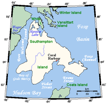
A closeup map of Southampton Island, Hudson Bay, Canada
Fisher Strait (63°N 084°W / 63°N 84°WCoordinates: 63°N 084°W / 63°N 84°W) is a natural waterway through the central Canadian Arctic Archipelago in the territory of Nunavut. It separates Southampton Island (to the north-west) from Coats Island (to the south-east). To the south-west the strait opens into Hudson Bay.
 WikiMiniAtlas
This Kivalliq Region, Nunavut location article is a stub. You can help Wikipedia by . |
Categories:
- Straits of Kivalliq Region
- Kivalliq Region, Nunavut geography stubs