Flåmsdalen
| Flåmsdalen | |
|---|---|
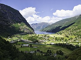 View of the village of Flåm and the Aurlandsfjorden at the north end of the valley. | |
 Flåmsdalen Location of the valley | |
| Length | 18 kilometres (11 mi) N-S |
| Geology | |
| Type | River valley |
| Geography | |
| Location | Vestland, Norway |
| Population centers | Flåm |
| Coordinates | 60°47′59″N 7°6′39″E / 60.79972°N 7.11083°ECoordinates: 60°47′59″N 7°6′39″E / 60.79972°N 7.11083°E |
| River | Flåmselvi |


Flåmsdalen is a valley in Aurland Municipality in Vestland county, Norway. It is 18 kilometers (11 mi) long and runs from Myrdal to the village of Flåm, dropping 860 meters (2,820 ft) over the course of its run. The river Flåmselvi runs through the valley, as does the Flåm Line, a famous tourist destination.[1]
Media gallery[]


References[]
- ^ Svein-Gunnar Selland. "Flåmsdalen". Store norske leksikon. Retrieved November 15, 2016.
External links[]
 Media related to Flåmsdalen at Wikimedia Commons
This Vestland location article is a stub. You can help Wikipedia by . |
Categories:
- Valleys of Vestland
- Aurland
- Vestland geography stubs