Flood embankment
This article needs additional citations for verification. (June 2016) |
A flood embankment is traditionally an earth wall used to shore up flood waters.
Most flood embankments are between 1 metre and 3 metres high. A 5-metre-high (16 ft) flood embankment is rare.[1]
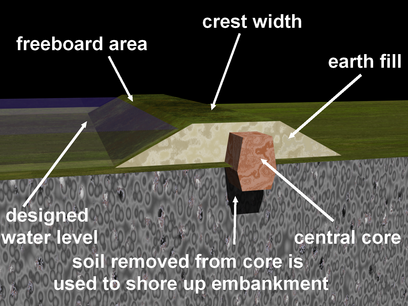
Modern improvements to this design include constructing an internal central core made from impermeable substance like clay or concrete, some even use metal pilings.[2]
Some authorities call man-made structures levees.
Problems[]
| Animation of types of floodwall failures | |
|---|---|
| Overtopping
some flood embankments are designed to overtop |
 |
| When not by design, the crest can wash away and cause a breach |  |
| Structural failure
If any weakness is detected under strong water pressure, the compromise is soon exacebated |
 |
| Rotation
When the structure has moved of its axis causing an exposed area to be washed away |
 |
| Sliding
When the structure has moved sideways exposing the foundation to erosion as well as allowing gaps in between the structures |
 |
| Seepage
When water infiltrates under the structure. This is caused by burrowing animals like dogs, beavers,badgers and otters |
 |
| Piping
When water finds its way under the structure and collects on the other side. A central core is normally designed in to prevent piping |
 |

 |
The main problem is the space required to construct and maintain such a structure.
A flood embankment of 2.5 metres high requires an outreach of 15 metres, which makes it unsuitable in some areas. To prevent seepage through the embankment a central core is added to acquire stability and integrity. |
 |
|---|
Examples[]

Clifton, Rawcliffe, Poppleton and Leeman ings in York
Animation[]

This is an animation showing a flood event overwhelming neighbouring properties and the added construction of a flood embankment and flood warning and protection status.
References[]
- ^ "Chapter 9". evidence.environment-agency.gov.uk. Retrieved 2016-05-01.
- ^ "Chapter 9". evidence.environment-agency.gov.uk. Retrieved 2016-05-01.
- Flood control