Floriańska Street
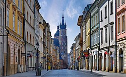 Floriańska Street with view of St. Mary's Church | |||
 Map of Kraków's Old Town, with Floriańska Street photo location marked in red | |||
| Native name | ulica Floriańska (Polish) | ||
|---|---|---|---|
| Length | 335 m (1,099 ft) | ||
| Width | 12 | ||
| Location | Kraków, Poland | ||
| Coordinates | 50°03′48″N 19°56′25″E / 50.0633°N 19.9402°ECoordinates: 50°03′48″N 19°56′25″E / 50.0633°N 19.9402°E | ||
| Construction | |||
| Commissioned | 1257 | ||

Floriańska Street or St. Florian's Street (Polish: ulica Floriańska, Latin: platea Sancti Floriani) is one of the main streets in Kraków Old Town and one of the most famous promenades in the city.[1] The street forms part of the regular grid plan of Stare Miasto (the Old Town), the merchants' town that extends the medieval heart of the city, which was drawn up in 1257 after the destruction of the city during the first Mongol invasion of Poland of 1241.[2]
Location[]

Floriańska appears on the 1257 plan of the extended city.[3] It marks the beginning of the Royal Road in Kraków[1] and stretches from the north-western end of the main square, Rynek Główny, to the landmark St. Florian's Gate, a distance of 335 metres (1,099 ft).[4] There are currently 51 numbered buildings on the street (up to no 44 even and no 57 odd).[4] It is named after Saint Florian.[5]
In 1882, the first horse tram line started. In 1901 it was transformed into the electricity line (now defunct).[6]
A number of notable landmarks and monuments, mainly kamienica-style buildings, are located on the street. They include buildings in the first half no 1, Kamienica pod Murzynami, no 2, Kamienica Mennica, no 13, Kamienica "Amendzińska" (also known as the Kmita Palace), no 14, the Hotel Pod Rózą, and later, the Pharmacy Museum of the Jagiellonian University Medical College at no 25, the Jan Matejko House at no 41, and the Jama Michalika cafe at no 45.[4] The north-western end of the street passes through St. Florian's Gate.[1]
Today, the street is a major tourist attraction, and most buildings feature shops, restaurants, cafes and similar establishments.[1] In 2007, the Polish magazine Wprost ranked Floriańska Street as the third most prestigious street in Poland, and the most prestigious in Kraków, following Warsaw's Nowy Świat (New World Street) and Krakowskie Przedmieście Street.[7] In 2011 and 2013, rents at Floriańska Street was the second highest in Poland, second only to that for Nowy Świat Street.[8][9]
References[]
- ^ a b c d "Florianska Street and Florianska Gate" (in Polish). Poland.pl. 2012-05-14. Archived from the original on 2014-02-03. Retrieved 2014-02-02.
- ^ Landmark Publishing; Andrew Beattie; Timothy Pepper (1 April 2002). Cracow. Landmark. p. 28. ISBN 978-1-84306-033-8.
- ^ Commentationes (in Polish). Państwowe Wydawn. Naukowe. 2009. p. 103.
Ulica Floriańska w Krakowie, łącząca Rvnek z Kleparzem i zwieńczona Bramą Floriańską. Została wytyczona w czasie wielkiej lokacji miasta w 1257 r. w miejsce dawnego traktu, łączącego Okół z osadą, rozwijającą się wokół XIl-wiecznego kościoła.
- ^ a b c krakow4u. "Ulica Florianska w Krakowie | Ulice miasta Krakowa". Krakow4u.pl. Retrieved 2014-02-02.
- ^ Krystyna Szymonowicz (1987). Droga Królewska na Wawel. Wydawn. PTTK "Kraj". p. 26. ISBN 978-83-7005-156-3.
- ^ "St. Florian's Gate and Florianska Street". Krakow.wiki. 2016-11-23. Retrieved 2019-04-18.
- ^ "Aleje sukcesu - strona 2 - WPROST". Wprost.pl. Retrieved 2014-02-02.
- ^ "Kraków: Floriańska drugą najdroższą ulicą Polski [ZDJĘCIA". Gazetakrakowska.pl. 2011-09-01. Retrieved 2014-02-02.
- ^ "Gdzie czynsze są najdroższe w kraju | rp.pl". Ekonomia.rp.pl. 2013-11-19. Archived from the original on 2014-02-19. Retrieved 2014-02-02.
Further reading[]
Jadwiga Kalinowska (1976). Ulica Floriańska: jej historia, zabytki, konserwacja. KKPM.
External links[]
| Wikimedia Commons has media related to Floriańska Street in Kraków. |
- Kraków ul. Floriańska i okolice, ekspozycje.org.pl
- Streets in Kraków
- Tourist attractions in Kraków
- 13th-century establishments in Poland