Floriano, Piauí
Floriano | |
|---|---|
Municipality | |
 Flag  Seal | |
| Nickname(s): Princesa do Sul | |
| Motto(s): Labor signum nostrum est — Work is our sign | |
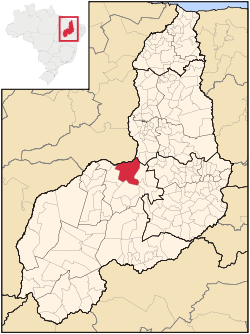 Location of Floriano in the State of Piauí | |
 | |
| Coordinates: 6°46′01″S 43°01′22″W / 6.76694°S 43.02278°WCoordinates: 6°46′01″S 43°01′22″W / 6.76694°S 43.02278°W | |
| Country | |
| Region | Northeast |
| State | |
| Founded | July 8, 1897 |
| Government | |
| • Mayor | Gilberto Junior (/PMDB)) |
| Area | |
| • Total | 3,409.664 km2 (1,316.479 sq mi) |
| Elevation | 112 m (367 ft) |
| Population (2020 [1]) | |
| • Total | 60,025 |
| • Density | 17.2/km2 (45/sq mi) |
| Time zone | -3 |
| HDI | 0.711 – medium [2] |
| Website | [1] |

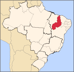
Floriano is a Brazilian municipality in the state of Piauí. It was founded by the Arabs and Syrians. It is situated in the physiographic zone of the Médio Parnaíba, on the right side of the Parnaíba River, in front of the city of Barão de Grajaú, in the Maranhão. It is also intersected by the rivers Gurguéia and Itaueira.
References[]
- ^ IBGE 2020
- ^ "Ranking decrescente do IDH-M dos municípios do Brasil". Atlas do Desenvolvimento Humano. Programa das Nações Unidas para o Desenvolvimento (PNUD). 2000. Archived from the original on 3 October 2009. Retrieved 11 October 2008.
External links[]
- Atlas Digital do Piauí (PDF), detailed facts about the municipalities in Piauí.
| hide Authority control | |
|---|---|
| General |
|
| National libraries | |
Categories:
- Municipalities in Piauí
- Populated places established in 1897