Florida, Cuba
Florida | |
|---|---|
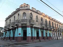 Facade of the Hotel Unión | |
 Florida municipality (red) within Camagüey Province (yellow) and Cuba | |
| Coordinates: 21°31′46″N 78°13′22″W / 21.52944°N 78.22278°WCoordinates: 21°31′46″N 78°13′22″W / 21.52944°N 78.22278°W | |
| Country | Cuba |
| Province | Camagüey |
| Founded | 1907 |
| Established | 1924[1] |
| Area | |
| • Total | 1,800 km2 (700 sq mi) |
| Elevation | 65 m (213 ft) |
| Population (2004)[3] | |
| • Total | 73,612 |
| • Density | 1,761/km2 (4,560/sq mi) |
| Time zone | UTC-5 (EST) |
| Area code(s) | +53-322 |
| Climate | Aw |


Florida (Spanish pronunciation: [floˈɾiða]) is a municipality and city in the Camagüey Province of Cuba. It is located 40 km (25 mi) north-west of Camagüey, along the Carretera Central highway. The city was established in 1907, and the municipality was established in 1924.[4] Of all the municipalities of the Cuban province of Camagüey, Florida is third in area size.[4] The name is Spanish for Land of flowers.
History[]
The town was founded in 1907 and, in 1949, the politician Francisco Díaz Marchand presented a project to turn it into an independent municipality. The project did not prosper, but in 1960 Manuel Frías Morales drafted a law to carry out the feasibility studies for the foundation of the municipality, but the opinion was adverse. Later, the Law #30 of June 14, 1971 created the municipality of Florida, one of the youngest of the island.
Geography[]
The municipality is located northwest of its province, next to the borders with Ciego de Ávila Province. Its elevation is represented by the Urabo Mountain with a height of 132.5 m. The bordering municipalities are Baraguá, Céspedes, Esmeralda, Camagüey and Vertientes.[5]
The municipal territory includes the villages and the localities of Alberto Becerra, , Conquista, El Angel, El Trece, La Alína, La Caridad, La Esperanza, La Jagua, La Porfuerza, La Serafina, , La Vallita, , Las Mercedes, Las Parras, Las Tusas, Los Güines, María Dos, María Seis, Manzanillo, Ortigal, Otero, Pérez Pérez, , , San Diego, San Faustino, San Jerónimo, Santa Gertrudis, Urabo and Vista Alegre. Until the 1977 municipal reform, it included the village of Magarabomba too,[1] currently part of Céspedes.
Demographics[]
In 2004, the municipality of Florida had a population of 73,612,[3] 53,847 of them in the town proper. With a total area of 1,800 km2 (690 sq mi),[2] it has a population density of 1,761/km2 (4,560/sq mi).
Health[]
Florida has 283 doctors, 187 of them are family physicians. There are 125 health facilities, including hospitals (a general and a pediatric one), clinics, pharmacies and laboratories.[4]
Education[]
There are 64 educational centers with a total of 15,013 students attending primary, secondary, and pre-university.[4] Florida also offers night schools with a range of educational careers for adults who can not attend during daylight hours.
Culture[]
Cultural Institutions[]
- Casa de Cultura "Luis Casas Romero"
- Biblioteca Pública Municipal "Rubén Martínez Villena"
- Biblioteca Pública "Tamara Bunke"
- Biblioteca Pública "Ignacio Agramonte"
- Florida Municipal Museum
- Casa de la Trova "Pedro Loforte Sablón"
- Banda Municipal de Concierto
- Librería Municipal "América Latina"
- Galería de Arte
- Centro Literario Municipal
- Museo General
- Cine Aurora
- Sala de Vídeo Comunidad Algarrobo
- Sala de Vídeo Comunidad San Antonio
- Sala de V��deo Agramonte
- Sala de Vídeo Micro Distrito
- Sala de Vídeo del Cementerio
Traditions[]
- Semana de la Cultura Floridana
- Carnaval Floridano
Transport[]

Florida is served by the "Central Railway" (Ferrocarril Central) Havana-Santiago, with local and long-distance trains. It is crossed by the national highway "Carretera Central" (CC) and, the future extension of the A1 motorway, will involve the town.
Personalities[]
- Ed Bauta (b. 1930), former baseball player
- (...–2013), politician and revolutionary[6]
- Ada Zayas-Bazán (b. 1958), writer
See also[]
References[]
- ^ Jump up to: a b Guije.com. "Florida" (in Spanish). Retrieved 2007-10-05.
- ^ Jump up to: a b Statoids. "Municipios of Cuba". Retrieved 2007-10-05.
- ^ Jump up to: a b Atenas.cu (2004). "2004 Population trends, by Province and Municipality" (in Spanish). Archived from the original on 2006-07-14. Retrieved 2007-10-05.
- ^ Jump up to: a b c d "Historia del Municipio Florida". Joven Club de Computación y Electrónica. Archived from the original on 2016-03-03. Retrieved 2015. Check date values in:
|accessdate=(help) - ^ 5892223 Florida on OpenStreetMap
- ^ (in Spanish) "The combatant Calixto Morales Hernández passed away". Granma, August 3, 2013
External links[]
| Wikimedia Commons has media related to Florida, Cuba. |
 Florida, Cuba travel guide from Wikivoyage
- (in Spanish) Florida on EcuRed
- (in Spanish) Camagüey-Florida
| show Places adjacent to Florida, Cuba |
|---|
| show Authority control |
|---|
- Florida, Cuba
- Cities in Cuba
- Populated places in Camagüey Province