Foot of Ten, Pennsylvania
Foot of Ten, Pennsylvania | |
|---|---|
 Foot of Ten Location within the state of Pennsylvania | |
| Coordinates: 40°24′57″N 78°27′19″W / 40.41583°N 78.45528°WCoordinates: 40°24′57″N 78°27′19″W / 40.41583°N 78.45528°W | |
| Country | United States |
| State | Pennsylvania |
| County | Blair |
| Townships | Allegheny, Juniata |
| Elevation | 1,106 ft (337 m) |
| Population (2010) | |
| • Total | 672 |
| Time zone | UTC-5 (Eastern (EST)) |
| • Summer (DST) | UTC-4 (EDT) |
| GNIS feature ID | 1174942[1] |

Foot of Ten is a census-designated place[2] in Allegheny and Juniata Townships in Blair County, Pennsylvania. It is located about a mile west of the small borough Duncansville on Foot of Ten Road, and about 2.5 miles (4 km) north of the even smaller borough Newry. It is often considered a region of Duncansville, despite lying outside of the borough limits. As of the 2010 census, the population was 672 residents.[3]
The town was named Foot of Ten because of its location at the foot of the tenth inclined plane of the Allegheny Portage Railroad.[4][5]
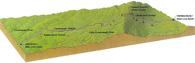
Profile of the original line of the portage railroad from Hollidaysburg, PA to Johnstown, PA. Foot of Ten lies just east of the inclined plane labeled 10.

See also[]
- Puzzletown, Pennsylvania a nearby unincorporated place on Puzzletown Road.
References[]
- ^ U.S. Geological Survey Geographic Names Information System: Foot of Ten, Pennsylvania
- ^ "Archived copy". Archived from the original on December 21, 2013. Retrieved February 10, 2013.
{{cite web}}: CS1 maint: archived copy as title (link) - ^ Bureau, US Census. "Census.gov". www.census.gov. Retrieved 2016-07-23.
- ^ "Allegheny Portage Railroad". History & Culture. National Park Service. Retrieved November 15, 2016.
- ^ "Funny Name". Foot of Ten Independent Baptist Church. Retrieved November 15, 2016.

Categories:
- Census-designated places in Blair County, Pennsylvania
- Census-designated places in Pennsylvania