Fort Ruger
| Fort Ruger | |
|---|---|
| Part of U.S. Army Coast Artillery Corps | |
| Honolulu, Hawaiʻi | |
| Site history | |
| Built | 1906 |
| In use | 1906–present |
Fort Ruger Historic District | |
 | |
| Location | Diamond Head Rd., Honolulu, Hawaii |
|---|---|
| Coordinates | 21°16′3″N 157°48′31″W / 21.26750°N 157.80861°WCoordinates: 21°16′3″N 157°48′31″W / 21.26750°N 157.80861°W |
| Built | 1911 |
| NRHP reference No. | 83000249 |
| Added to NRHP | July 14, 1983[1] |

Fort Ruger is a fort on the island of Oʻahu that served as the first military reservation in the Territory of Hawaii. Named after Civil War General Thomas H. Ruger and built in and around Diamond Head Crater, the fort was established by the United States for the purpose of defending the harbor of its newly annexed territory.[2] The fort was established in 1906 as Diamond Head Reservation[3] and renamed Fort Ruger in 1909.[4]
History[]
Fort Ruger was the site of Battery Harlow, armed with eight 12-inch mortars.[5] The fort's prominent location on Diamond Head made it a natural fire control station, with several posts built into Lēʻahi Peak.[5][6]
The Fort is listed on the National Register of Historic Places,[7] with portions of the site still being used for training by the Hawaii National Guard.[8][9]
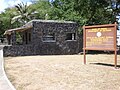
Few of the original buildings survive. The most striking are three sets of stone structures that mark former gates to the fort. On the Waikiki side, there is a pair of gateposts on either side of the sidewalk and a square stone bunker across the street with a gun slit in the outside wall and with crenels and merlons along the top, as if it were a battlement in a European castle. On the Kahala side is a larger stone gatehouse with rounded edges of the kind popular in the 1930s. Between them, on the Kaimuki side, is a purely decorative structure, a circular stonewalled planter with two jagged stone arches intersecting at 90-degree angles. It now stands at the edge of the Kapiolani Community College parking lot, but was once flanked by two large gun barrels.[10]
Images[]
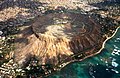
Aerial view of Diamond Head Crater
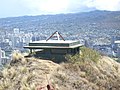
Bunker on ridge of Diamond Head

Battery Harlow as seen from Diamond Head Road
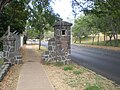
Old entrance gatepost, Waikiki side

Old gate guardhouse, Waikiki side

Stone artwork, Kaimuki side
Old gatehouse & current signpost, Kahala side
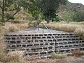
Stairs that led to the old Cannon Club
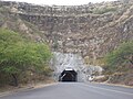
Tunnel into Diamond Head Crater
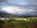
View over Kahala toward Koko Head


See also[]
References[]
- ^ "National Register Information System". National Register of Historic Places. National Park Service. April 15, 2008.
- ^ "Fort Ruger Soil Reclamation Project - Fact Sheet No. 1" (PDF). Archived from the original (PDF) on 2006-10-08. Retrieved 2008-02-21.
- ^ Executive Order 395-A
- ^ "General Orders, No. 15, War Dept., January 28, 1909".
- ^ a b "American Seacoast Defenses Forts, Military Reservations and Batteries 1794-1945: Oahu 1922" (PDF). Coast Defense Study Group (cdsg.org). Retrieved January 19, 2018.
- ^ Williford, Glen, Terrance McGovern, Chris Taylor. Defenses of Pearl Harbor and Oahu 1907-50, pp. 16–18. Osprey Publishing, 2003. ISBN 978-1-84176-572-3
- ^ "National Register of Historical Places - Hawaii (HI), Honolulu County". Retrieved 2008-02-21.
- ^ "World War II fortifications still present on Oʻahu". The Honolulu Advertiser. 2002-03-26. Retrieved 2008-02-21.
- ^ Fawcett, Denby (August 3, 2014). "Tunnel Vision". Star-Advertiser. Honolulu. Archived from the original on February 1, 2018. Retrieved January 31, 2018. Alt URL
- ^ Brown, DeSoto. (2003), "Fort Ruger" in David Cheever and Scott Cheever, Pōhaku: The Art & Architecture of Stonework in Hawaiʻi (Honolulu: Editions Limited), pp. 88–89. ISBN 978-0-915013-23-4
| Wikimedia Commons has media related to Fort Ruger. |
| Topics | |
|---|---|
| Lists by state |
|
| Lists by insular areas | |
| Lists by associated state | |
| Other areas | |
| Related | |
| |
- Coastal artillery
- Forts in Hawaii
- Buildings and structures in Honolulu
- Territory of Hawaii
- Forts on the National Register of Historic Places in Hawaii
- 1906 establishments in Hawaii
- Protected areas established in 1983
- Historic districts on the National Register of Historic Places in Hawaii
- National Register of Historic Places in Honolulu