Fourges
Fourges | |
|---|---|
Part of Vexin-sur-Epte | |
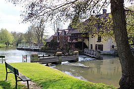 Mill | |
show Location of Fourges | |
 Fourges | |
| Coordinates: 49°07′19″N 1°38′28″E / 49.1219°N 1.6411°ECoordinates: 49°07′19″N 1°38′28″E / 49.1219°N 1.6411°E | |
| Country | France |
| Region | Normandy |
| Department | Eure |
| Arrondissement | Les Andelys |
| Canton | Les Andelys |
| Commune | Vexin-sur-Epte |
| Area 1 | 7.72 km2 (2.98 sq mi) |
| Population (2017)[1] | 770 |
| • Density | 100/km2 (260/sq mi) |
| Time zone | UTC+01:00 (CET) |
| • Summer (DST) | UTC+02:00 (CEST) |
| Postal code | 27630 |
| Elevation | 20–142 m (66–466 ft) (avg. 33 m or 108 ft) |
| 1 French Land Register data, which excludes lakes, ponds, glaciers > 1 km2 (0.386 sq mi or 247 acres) and river estuaries. | |


Fourges is a former commune in the Eure department in the Normandy region in northern France. On 1 January 2016, it was merged into the new commune of Vexin-sur-Epte.[2]
Population[]
| Year | Pop. | ±% |
|---|---|---|
| 1962 | 312 | — |
| 1968 | 321 | +2.9% |
| 1975 | 419 | +30.5% |
| 1982 | 453 | +8.1% |
| 1990 | 685 | +51.2% |
| 1999 | 772 | +12.7% |
| 2008 | 816 | +5.7% |
See also[]
- Communes of the Eure department
- Cahaignes, a close municipality in the same department
References[]
- ^ Téléchargement du fichier d'ensemble des populations légales en 2017, INSEE
- ^ Arrêté préfectoral 4 December 2015 (in French)
| Wikimedia Commons has media related to Fourges. |
This Eure geographical article is a stub. You can help Wikipedia by . |
Categories:
- Former communes of Eure
- Eure geography stubs