Frączków
Frączków | |
|---|---|
Village | |
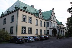 Palace in the village | |
 Frączków Location in Poland | |
| Coordinates: 50°32′18″N 17°18′37″E / 50.53833°N 17.31028°ECoordinates: 50°32′18″N 17°18′37″E / 50.53833°N 17.31028°E | |
| Country | |
| Voivodeship | Opole |
| County | Nysa |
| Gmina | Pakosławice |

Frączków [ˈfrɔnt͡ʂkuf] (German: Franzdorf) is a village in the administrative district of Gmina Pakosławice, within Nysa County, Opole Voivodeship, in south-western Poland.[1]
Before 1945 the area was part of Germany (see Territorial changes of Poland after World War II).
References[]
| hide | ||
|---|---|---|
| Seat |  | |
| Other villages | ||
This Nysa County article is a stub. You can help Wikipedia by . |
Categories:
- Villages in Nysa County
- Nysa County geography stubs