Franklin Island (Greenland)
| |
|---|---|
 Nares strait border (Kennedy channel) | |
 Franklin Island | |
| Geography | |
| Coordinates | 80°38′N 66°49′W / 80.633°N 66.817°WCoordinates: 80°38′N 66°49′W / 80.633°N 66.817°W |
| Archipelago | Greenland |
| Highest elevation | 215 m (705 ft) |
| Administration | |

Franklin Island (Danish: Franklin Ø) is one of three islands located in Kennedy Channel of Nares Strait in the high Arctic and is part of Avannaata municipality, Greenland.
Geography[]
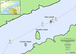
Franklin Island is the largest of a group of three islands off the Washington Land coast that includes Crozier Island and Hans Island as well. The former is also part of Greenland, whilst the latter's ownership is disputed between Denmark and Canada.
It is located c. 3 miles (4.8 km) north of (Danish: Kap Constitution). It is predominantly light brown in colour, very steep-sided, flat topped, and rises to a height of 215 m (705 ft) on the Southeast side.[1]
The island is named after the British explorer John Franklin (1786–1847), by Elisha Kent Kane between 1854 and 1855 during his second Grinnell Expedition, after it was sighted by Hans Hendrik and the American in June 1854.
See also[]
References[]
- ^ "Franklin Ø". Mapcarta. Retrieved 8 April 2016.
This Greenland location article is a stub. You can help Wikipedia by . |
- Islands of Greenland
- Greenland geography stubs