Fresno de Cantespino
This article does not cite any sources. (October 2009) |
Fresno de Cantespino | |
|---|---|
 | |
 Flag  Seal | |
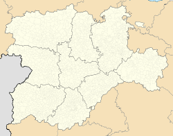 Fresno de Cantespino Location in Spain. | |
| Coordinates: 41°22′10″N 3°29′50″W / 41.36944°N 3.49722°W | |
| Country | |
| Autonomous community | |
| Province | |
| Municipality | Fresno de Cantespino |
| Area | |
| • Total | 63.33 km2 (24.45 sq mi) |
| Elevation | 1,037 m (3,402 ft) |
| Population (2018)[1] | |
| • Total | 262 |
| • Density | 4.1/km2 (11/sq mi) |
| Time zone | UTC+1 (CET) |
| • Summer (DST) | UTC+2 (CEST) |
| Website | Official website |


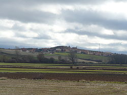
Fresno de Cantespino is a municipality located in the province of Segovia, Castile and León, Spain. According to the 2004 census (INE), the municipality had a population of 290.

Iglesia de San Nicolás de Bari, of Roman origin.

Iglesia de Cascajares, built in the 16th century.

Ancient street's poster
References[]
- ^ Municipal Register of Spain 2018. National Statistics Institute.
| Wikimedia Commons has media related to Fresno de Cantespino. |
| show Authority control |
|---|
This article about a location in the province of Segovia, Spain is a stub. You can help Wikipedia by . |
Categories:
- Municipalities in the Province of Segovia
- Province of Segovia geography stubs